Ndikiniméki geodata
Ndikiniméki (Centre) is a populated place; located in Cameroon in Africa/Douala (GMT+1) time zone. With population of 8,247 people, there are 78 cities with bigger population in this country. Compared to other cities in Cameroon, 53.3% of cities are located further ↑North; 52.5% of cities are located further →East and 68% of cities have lower elevation than Ndikiniméki. Note1


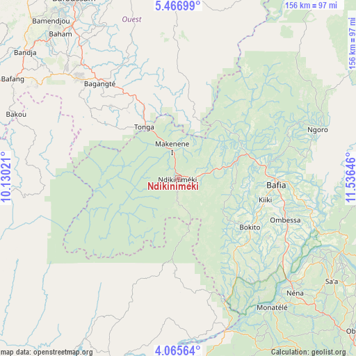
Ndikiniméki GPS coordinates[2]
4° 46' 0.012" North, 10° 49' 59.988" East
| Map corner | latitude | longitude |
|---|---|---|
| Upper-left | 5.46699°, | 10.13021° |
| Center: | 4.76667°, | 10.83333° |
| Lower-right: | 4.06564°, | 11.53646° |
| Map W x H: | 155.8×155.8 km | = 96.8×96.8mi |
| max Lat: | 12.57535° ⇑53.3% North |
| Ndikiniméki: | 4.76667° |
| min Lat: | ⇓46.7% South 2.35° |
| min Long | Ndikiniméki | max Long |
| 8.8724° | 10.83333° | 15.23288° |
| W 47.5%⇐ | ⇒52.5% E |
Elevation
Elevation of Ndikiniméki is 803 m = 2635 ft, and this is 129.1 m = 424 ft above average elevation for this country.
| Max E: |
1687 m = 5535 ft | 32% |
| Ndikiniméki | 803 m 2635 ft | |
| Avg. | 673.9 m = 2211 ft | |
Min E: |
1 m = 3 ft | 68% |
See also: Cameroon elevation on elevation.city.
Geographical zone
Ndikiniméki is located in North Torrid zone (between Equator and Tropic of Cancer). Distance of Equator is 530 km =329.3 mi to South.| Distance of | km | miles | from Ndikiniméki |
|---|---|---|---|
| North Pole | 9477.1 | 5888.8 | to North |
| Arctic Circle | 6871.2 | 4269.6 | to North |
| Tropic Cancer | 2075.9 | 1289.9 | to North |
| Equator | 530 | 329.3 | to South |


Nearby cities:
15 places around Ndikiniméki: (largest is in red/bold)
• Bafang
84.7 km =52.6 mi,  300°
300°
• Bafia
44.4 km =27.6 mi,  92°
92°
• Bamendjou
88.9 km =55.2 mi,  321°
321°
• Bana
74.9 km =46.5 mi, 304°
• Bandjoun
82.2 km =51.1 mi,  325°
325°
• Bangangté
53.8 km =33.4 mi, 320°
• Bazou
52 km =32.3 mi,  308°
308°
• Foumbot
85.4 km =53.1 mi,  344°
344°
• Ngambé
64 km =39.8 mi,  202°
202°
• Ngoro
64.3 km =40 mi,  71°
71°
• Ngou
68.9 km =42.8 mi, 313°
• Ombésa
49.8 km =30.9 mi,  111°
111°
• Saa
81.5 km =50.6 mi,  123°
123°
• Tonga
26.7 km =16.6 mi, 326°
• Évodoula
86.2 km =53.6 mi,  151°
151°
Sources, notices
• [Note1] Compared only with cities in Cameroon existing in our database
• [Src1] Map data: © OpenStreetMap contributors (CC-BY-SA)
• [Src2] Other city data from geonames.org with taken over terms of usage.
• [Src3] Geographical zone / Annual Mean Temperature by Robert A. Rohde @ Wikipedia
