Sihe geodata
Sihe (Guangdong) is a seat of a fourth-order administrative division; located in China in Asia/Urumqi (GMT+6) time zone. In our database, there are 1268 cities with bigger population. Compared to other cities in China, 96.5% of cities are located further ↑North; 64.6% of cities are located further →East and 53.5% of cities have lower elevation than Sihe. Note1


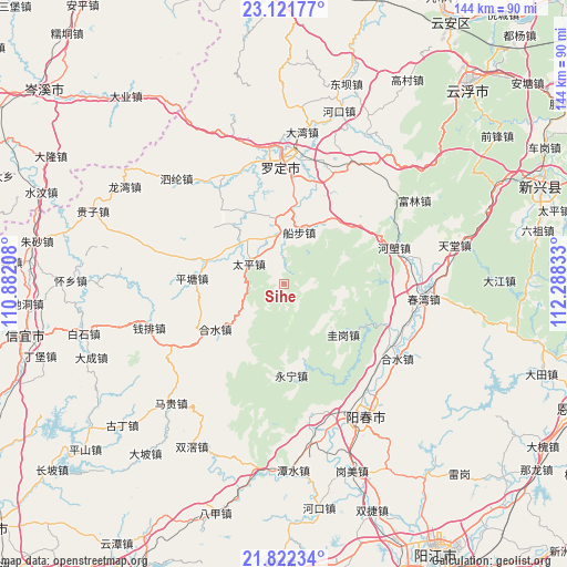
Sihe GPS coordinates[2]
22° 28' 24.888" North, 111° 35' 6.72" East
| Map corner | latitude | longitude |
|---|---|---|
| Upper-left | 23.12177°, | 110.88208° |
| Center: | 22.47358°, | 111.5852° |
| Lower-right: | 21.82234°, | 112.28833° |
| Map W x H: | 144.5×144.5 km | = 89.8×89.8mi |
| max Lat: | 53.31946° ⇑96.5% North |
| Sihe: | 22.47358° |
| min Lat: | ⇓3.5% South 18.22056° |
| min Long | Sihe | max Long |
| 75.07348° | 111.5852° | 134.28917° |
| W 35.4%⇐ | ⇒64.6% E |
Elevation
Elevation of Sihe is 193 m = 633 ft, and this is 291.8 m = 957 ft below average elevation for this country.
| Max E: |
5622 m = 18445 ft | 46.5% |
| Avg. | 484.8 m = 1591 ft | |
| Sihe | 193 m = 633 ft | |
Min E: |
-3 m = -10 ft | 53.5% |
See also: China elevation on elevation.city.
Geographical zone
Sihe is located in North Torrid zone (between Equator and Tropic of Cancer). Distance of this Northern Tropic circle is 107.1 km =66.5 mi to North.| Distance of | km | miles | from Sihe |
|---|---|---|---|
| North Pole | 7508.2 | 4665.4 | to North |
| Arctic Circle | 4902.3 | 3046.1 | to North |
| Tropic Cancer | 107.1 | 66.5 | to North |
| Equator | 2498.8 | 1552.7 | to South |


Nearby cities:
15 places around Sihe: (largest is in red/bold)
• Bingtang
20.7 km =12.9 mi,  36°
36°
• Chuanbu
13.7 km =8.5 mi,  16°
16°
• Fenjie
26.2 km =16.3 mi,  290°
290°
• Guigang
19.8 km =12.3 mi,  130°
130°
• Heshui
21.5 km =13.4 mi,  237°
237°
• Lianzhou
23.8 km =14.8 mi,  319°
319°
• Luojing
16.4 km =10.2 mi,  297°
297°
• Luoping
16.9 km =10.5 mi,  353°
353°
• Pingtang
24.1 km =15 mi,  272°
272°
• Shengjiang
27.1 km =16.8 mi,  343°
343°
• Sulong
27.2 km =16.9 mi,  5°
5°
• Taiping
10.4 km =6.5 mi, 299°
• Weidi
27.9 km =17.3 mi, 17°
• Xinbao
16.3 km =10.1 mi,  230°
230°
• Yongning
23.4 km =14.5 mi,  175°
175°
Sources, notices
• [Note1] Compared only with cities in China existing in our database
• [Src1] Map data: © OpenStreetMap contributors (CC-BY-SA)
• [Src2] Other city data from geonames.org with taken over terms of usage.
• [Src3] Geographical zone / Annual Mean Temperature by Robert A. Rohde @ Wikipedia
