Heshui geodata
Heshui (Guangdong) is a seat of a fourth-order administrative division; located in China in Asia/Urumqi (GMT+6) time zone. In our database, there are 1268 cities with bigger population. Compared to other cities in China, 96.6% of cities are located further ↑North; 65.4% of cities are located further →East and 56.7% of cities have lower elevation than Heshui. Note1


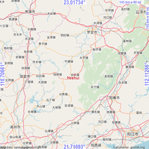
Heshui GPS coordinates[2]
22° 22' 7.14" North, 111° 24' 35.028" East
| Map corner | latitude | longitude |
|---|---|---|
| Upper-left | 23.01734°, | 110.70661° |
| Center: | 22.36865°, | 111.40973° |
| Lower-right: | 21.71693°, | 112.11286° |
| Map W x H: | 144.6×144.6 km | = 89.9×89.9mi |
| max Lat: | 53.31946° ⇑96.6% North |
| Heshui: | 22.36865° |
| min Lat: | ⇓3.4% South 18.22056° |
| min Long | Heshui | max Long |
| 75.07348° | 111.40973° | 134.28917° |
| W 34.6%⇐ | ⇒65.4% E |
Elevation
Elevation of Heshui is 223 m = 732 ft, and this is 261.8 m = 859 ft below average elevation for this country.
| Max E: |
5622 m = 18445 ft | 43.3% |
| Avg. | 484.8 m = 1591 ft | |
| Heshui | 223 m = 732 ft | |
Min E: |
-3 m = -10 ft | 56.7% |
See also: China elevation on elevation.city.
Geographical zone
Heshui is located in North Torrid zone (between Equator and Tropic of Cancer). Distance of this Northern Tropic circle is 118.8 km =73.8 mi to North.| Distance of | km | miles | from Heshui |
|---|---|---|---|
| North Pole | 7519.9 | 4672.6 | to North |
| Arctic Circle | 4914 | 3053.4 | to North |
| Tropic Cancer | 118.8 | 73.8 | to North |
| Equator | 2487.2 | 1545.5 | to South |


Nearby cities:
15 places around Heshui: (largest is in red/bold)
• Baishi
32.5 km =20.2 mi,  267°
267°
• Dacheng
32.3 km =20.1 mi,  255°
255°
• Fenjie
21.7 km =13.5 mi,  342°
342°
• Guding
32.6 km =20.3 mi,  222°
222°
• Hongguan
28.7 km =17.8 mi,  288°
288°
• Lianzhou
29.8 km =18.5 mi,  4°
4°
• Luojing
19.5 km =12.1 mi,  10°
10°
• Magui
20.9 km =13 mi,  208°
208°
• Pingtang
14.1 km =8.8 mi,  334°
334°
• Qianpai
15.3 km =9.5 mi, 268°
• Shuangjiao
30.5 km =19 mi,  189°
189°
• Sihe
21.5 km =13.4 mi,  57°
57°
• Taiping
19.1 km =11.9 mi,  28°
28°
• Xinbao
5.6 km =3.5 mi,  75°
75°
• Yongning
23 km =14.3 mi,  120°
120°
Sources, notices
• [Note1] Compared only with cities in China existing in our database
• [Src1] Map data: © OpenStreetMap contributors (CC-BY-SA)
• [Src2] Other city data from geonames.org with taken over terms of usage.
• [Src3] Geographical zone / Annual Mean Temperature by Robert A. Rohde @ Wikipedia
