Zhihe geodata
Zhihe (Shanxi) is a seat of a third-order administrative division; located in China in Asia/Shanghai (GMT+8) time zone. In our database, there are 1268 cities with bigger population. Compared to other cities in China, 78.7% of cities are located further ↓South; 68.5% of cities are located further →East and 83.9% of cities have lower elevation than Zhihe. Note1


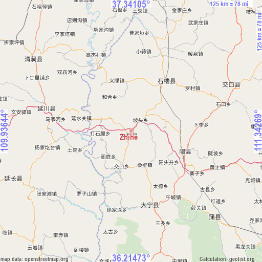
Zhihe GPS coordinates[2]
36° 46' 47.856" North, 110° 38' 22.416" East
| Map corner | latitude | longitude |
|---|---|---|
| Upper-left | 37.34105°, | 109.93644° |
| Center: | 36.77996°, | 110.63956° |
| Lower-right: | 36.21473°, | 111.34269° |
| Map W x H: | 125.2×125.2 km | = 77.8×77.8mi |
| max Lat: | 53.31946° ⇑21.3% North |
| Zhihe: | 36.77996° |
| min Lat: | ⇓78.7% South 18.22056° |
| min Long | Zhihe | max Long |
| 75.07348° | 110.63956° | 134.28917° |
| W 31.5%⇐ | ⇒68.5% E |
Elevation
Elevation of Zhihe is 911 m = 2989 ft, and this is 426.2 m = 1398 ft above average elevation for this country.
| Max E: |
5622 m = 18445 ft | 16.1% |
| Zhihe | 911 m 2989 ft | |
| Avg. | 484.8 m = 1591 ft | |
Min E: |
-3 m = -10 ft | 83.9% |
See also: China elevation on elevation.city.
Geographical zone
Zhihe is located in North temperate zone (between Tropic of Cancer and the Arctic Circle). Distance of this Northern Tropic circle is 1483.6 km =921.9 mi to South.| Distance of | km | miles | from Zhihe |
|---|---|---|---|
| North Pole | 5917.5 | 3677 | to North |
| Arctic Circle | 3311.6 | 2057.7 | to North |
| Tropic Cancer | 1483.6 | 921.9 | to South |
| Equator | 4089.5 | 2541.1 | to South |


Nearby cities:
15 places around Zhihe: (largest is in red/bold)
• Changning
90.5 km =56.2 mi,  169°
169°
• Cuifeng
101.9 km =63.3 mi,  85°
85°
• Jichang
75.5 km =46.9 mi,  177°
177°
• Lingquan
30.4 km =18.9 mi,  36°
36°
• Lishi
92.8 km =57.7 mi,  28°
28°
• Liulin
78.4 km =48.7 mi,  17°
17°
• Longquan
29.7 km =18.5 mi,  108°
108°
• Ningxiang
80 km =49.7 mi, 38°
• Nongchangbalian
101.8 km =63.3 mi,  243°
243°
• Pucheng
57.6 km =35.8 mi,  135°
135°
• Shuitou
55 km =34.2 mi,  67°
67°
• Xiangling
107.9 km =67 mi, 140°
• Xinshui
35.1 km =21.8 mi,  162°
162°
• Xinzhi
100 km =62.1 mi, 108°
• Yong’an
83.7 km =52 mi,  99°
99°
Sources, notices
• [Note1] Compared only with cities in China existing in our database
• [Src1] Map data: © OpenStreetMap contributors (CC-BY-SA)
• [Src2] Other city data from geonames.org with taken over terms of usage.
• [Src3] Geographical zone / Annual Mean Temperature by Robert A. Rohde @ Wikipedia
