Cuifeng geodata
Cuifeng (Shanxi) is a seat of a third-order administrative division; located in China in Asia/Shanghai (GMT+8) time zone. In our database, there are 1268 cities with bigger population. Compared to other cities in China, 78.8% of cities are located further ↓South; 63.6% of cities are located further →East and 82.4% of cities have lower elevation than Cuifeng. Note1


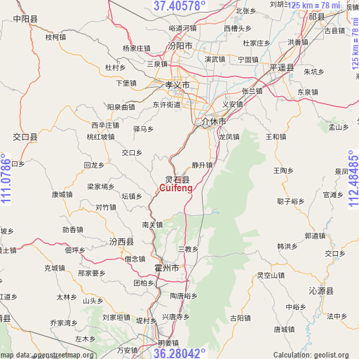
Cuifeng GPS coordinates[2]
36° 50' 42.612" North, 111° 46' 54.192" East
| Map corner | latitude | longitude |
|---|---|---|
| Upper-left | 37.40578°, | 111.0786° |
| Center: | 36.84517°, | 111.78172° |
| Lower-right: | 36.28042°, | 112.48485° |
| Map W x H: | 125.1×125.1 km | = 77.7×77.7mi |
| max Lat: | 53.31946° ⇑21.2% North |
| Cuifeng: | 36.84517° |
| min Lat: | ⇓78.8% South 18.22056° |
| min Long | Cuifeng | max Long |
| 75.07348° | 111.78172° | 134.28917° |
| W 36.4%⇐ | ⇒63.6% E |
Elevation
Elevation of Cuifeng is 811 m = 2661 ft, and this is 326.2 m = 1070 ft above average elevation for this country.
| Max E: |
5622 m = 18445 ft | 17.6% |
| Cuifeng | 811 m 2661 ft | |
| Avg. | 484.8 m = 1591 ft | |
Min E: |
-3 m = -10 ft | 82.4% |
See also: China elevation on elevation.city.
Geographical zone
Cuifeng is located in North temperate zone (between Tropic of Cancer and the Arctic Circle). Distance of this Northern Tropic circle is 1490.9 km =926.4 mi to South.| Distance of | km | miles | from Cuifeng |
|---|---|---|---|
| North Pole | 5910.3 | 3672.5 | to North |
| Arctic Circle | 3304.4 | 2053.3 | to North |
| Tropic Cancer | 1490.9 | 926.4 | to South |
| Equator | 4096.8 | 2545.6 | to South |


Nearby cities:
15 places around Cuifeng: (largest is in red/bold)
• Dahuaishu
65.1 km =40.5 mi,  188°
188°
• Dingchang
81.1 km =50.4 mi,  96°
96°
• Fengcheng
68.8 km =42.8 mi,  18°
18°
• Gutao
53.1 km =33 mi,  41°
41°
• Jiexiu
23.1 km =14.4 mi,  30°
30°
• Longquan
75.4 km =46.9 mi,  257°
257°
• Ningxiang
75.1 km =46.7 mi,  317°
317°
• Pucheng
77.8 km =48.3 mi,  231°
231°
• Qinhe
61.7 km =38.3 mi,  128°
128°
• Shuitou
52.9 km =32.9 mi,  285°
285°
• Tianning
85 km =52.8 mi, 23°
• Xinzhi
39.1 km =24.3 mi, 190°
• Yong’an
28.3 km =17.6 mi,  222°
222°
• Yueyang
62.9 km =39.1 mi,  169°
169°
• Zhaoyu
73.9 km =45.9 mi, 39°
Sources, notices
• [Note1] Compared only with cities in China existing in our database
• [Src1] Map data: © OpenStreetMap contributors (CC-BY-SA)
• [Src2] Other city data from geonames.org with taken over terms of usage.
• [Src3] Geographical zone / Annual Mean Temperature by Robert A. Rohde @ Wikipedia
