Maikun geodata
Maikun (Sichuan) is a seat of a fourth-order administrative division; located in China in Asia/Shanghai (GMT+8) time zone. In our database, there are 1268 cities with bigger population. Compared to other cities in China, 65.6% of cities are located further ↓South; 93.1% of cities are located further →East and 97.5% of cities have lower elevation than Maikun. Note1


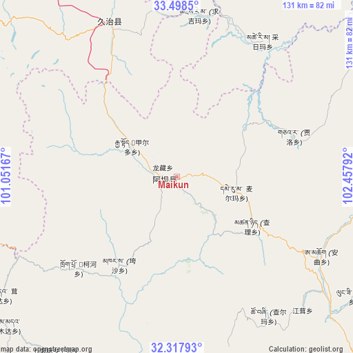
Maikun GPS coordinates[2]
32° 54' 36.648" North, 101° 45' 17.244" East
| Map corner | latitude | longitude |
|---|---|---|
| Upper-left | 33.4985°, | 101.05167° |
| Center: | 32.91018°, | 101.75479° |
| Lower-right: | 32.31793°, | 102.45792° |
| Map W x H: | 131.3×131.3 km | = 81.6×81.6mi |
| max Lat: | 53.31946° ⇑34.4% North |
| Maikun: | 32.91018° |
| min Lat: | ⇓65.6% South 18.22056° |
| min Long | Maikun | max Long |
| 75.07348° | 101.75479° | 134.28917° |
| W 6.9%⇐ | ⇒93.1% E |
Elevation
Elevation of Maikun is 3344 m = 10971 ft, and this is 2859.2 m = 9381 ft above average elevation for this country.
| Max E: |
5622 m = 18445 ft | 2.5% |
| Maikun | 3344 m 10971 ft | |
| Avg. | 484.8 m = 1591 ft | |
Min E: |
-3 m = -10 ft | 97.5% |
See also: China elevation on elevation.city.
Geographical zone
Maikun is located in North temperate zone (between Tropic of Cancer and the Arctic Circle). Distance of this Northern Tropic circle is 1053.4 km =654.6 mi to South.| Distance of | km | miles | from Maikun |
|---|---|---|---|
| North Pole | 6347.8 | 3944.3 | to North |
| Arctic Circle | 3741.9 | 2325.1 | to North |
| Tropic Cancer | 1053.4 | 654.6 | to South |
| Equator | 3659.3 | 2273.8 | to South |


Nearby cities:
15 places around Maikun: (largest is in red/bold)
• Aba
4.6 km =2.9 mi,  264°
264°
• Andou
21.9 km =13.6 mi,  297°
297°
• Cairima
60.8 km =37.8 mi,  38°
38°
• Dege
11.7 km =7.3 mi,  277°
277°
• Gemo
17.2 km =10.7 mi,  305°
305°
• Hezhi
10.1 km =6.3 mi,  271°
271°
• Jia’erduo
20.3 km =12.6 mi, 304°
• Kehe
49.3 km =30.6 mi,  224°
224°
• Kuasha
39.3 km =24.4 mi,  213°
213°
• Longcang
5.9 km =3.7 mi, 305°
• Qihama
56.6 km =35.2 mi,  22°
22°
• Qiujima
62.2 km =38.6 mi,  349°
349°
• Rong’an
44.8 km =27.8 mi,  198°
198°
• Wa’erma
3.6 km =2.2 mi,  294°
294°
• Zhiqing Songduo
65.4 km =40.6 mi,  332°
332°
Sources, notices
• [Note1] Compared only with cities in China existing in our database
• [Src1] Map data: © OpenStreetMap contributors (CC-BY-SA)
• [Src2] Other city data from geonames.org with taken over terms of usage.
• [Src3] Geographical zone / Annual Mean Temperature by Robert A. Rohde @ Wikipedia
