Andou geodata
Andou (Sichuan) is a seat of a fourth-order administrative division; located in China in Asia/Shanghai (GMT+8) time zone. In our database, there are 1268 cities with bigger population. Compared to other cities in China, 66% of cities are located further ↓South; 93.4% of cities are located further →East and 97.7% of cities have lower elevation than Andou. Note1


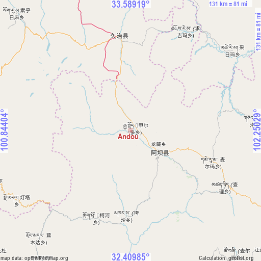
Andou GPS coordinates[2]
33° 0' 5.364" North, 101° 32' 49.776" East
| Map corner | latitude | longitude |
|---|---|---|
| Upper-left | 33.58919°, | 100.84404° |
| Center: | 33.00149°, | 101.54716° |
| Lower-right: | 32.40985°, | 102.25029° |
| Map W x H: | 131.1×131.1 km | = 81.5×81.5mi |
| max Lat: | 53.31946° ⇑34% North |
| Andou: | 33.00149° |
| min Lat: | ⇓66% South 18.22056° |
| min Long | Andou | max Long |
| 75.07348° | 101.54716° | 134.28917° |
| W 6.6%⇐ | ⇒93.4% E |
Elevation
Elevation of Andou is 3450 m = 11319 ft, and this is 2965.2 m = 9728 ft above average elevation for this country.
| Max E: |
5622 m = 18445 ft | 2.3% |
| Andou | 3450 m 11319 ft | |
| Avg. | 484.8 m = 1591 ft | |
Min E: |
-3 m = -10 ft | 97.7% |
See also: China elevation on elevation.city.
Geographical zone
Andou is located in North temperate zone (between Tropic of Cancer and the Arctic Circle). Distance of this Northern Tropic circle is 1063.5 km =660.8 mi to South.| Distance of | km | miles | from Andou |
|---|---|---|---|
| North Pole | 6337.6 | 3938 | to North |
| Arctic Circle | 3731.8 | 2318.8 | to North |
| Tropic Cancer | 1063.5 | 660.8 | to South |
| Equator | 3669.4 | 2280.1 | to South |


Nearby cities:
15 places around Andou: (largest is in red/bold)
• Aba
18.3 km =11.4 mi,  125°
125°
• Dege
11.5 km =7.1 mi,  137°
137°
• Dimda
67.1 km =41.7 mi,  238°
238°
• Gemo
5.5 km =3.4 mi,  91°
91°
• Hezhi
13.5 km =8.4 mi, 136°
• Jia’erduo
3 km =1.9 mi,  63°
63°
• Kehe
47.9 km =29.8 mi,  198°
198°
• Kuasha
43.1 km =26.8 mi,  182°
182°
• Longcang
16 km =9.9 mi,  114°
114°
• Maikun
21.9 km =13.6 mi,  117°
117°
• Qihama
58.7 km =36.5 mi,  44°
44°
• Qiujima
51.5 km =32 mi,  8°
8°
• Rong’an
52.7 km =32.7 mi,  174°
174°
• Wa’erma
18.3 km =11.4 mi, 118°
• Zhiqing Songduo
49.2 km =30.6 mi,  347°
347°
Sources, notices
• [Note1] Compared only with cities in China existing in our database
• [Src1] Map data: © OpenStreetMap contributors (CC-BY-SA)
• [Src2] Other city data from geonames.org with taken over terms of usage.
• [Src3] Geographical zone / Annual Mean Temperature by Robert A. Rohde @ Wikipedia
