Longcang geodata
Longcang (Sichuan) is a seat of a fourth-order administrative division; located in China in Asia/Shanghai (GMT+8) time zone. In our database, there are 1268 cities with bigger population. Compared to other cities in China, 65.8% of cities are located further ↓South; 93.2% of cities are located further →East and 97.6% of cities have lower elevation than Longcang. Note1


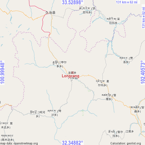
Longcang GPS coordinates[2]
32° 56' 27.132" North, 101° 42' 9.36" East
| Map corner | latitude | longitude |
|---|---|---|
| Upper-left | 33.52898°, | 100.99948° |
| Center: | 32.94087°, | 101.7026° |
| Lower-right: | 32.34882°, | 102.40573° |
| Map W x H: | 131.2×131.2 km | = 81.5×81.5mi |
| max Lat: | 53.31946° ⇑34.2% North |
| Longcang: | 32.94087° |
| min Lat: | ⇓65.8% South 18.22056° |
| min Long | Longcang | max Long |
| 75.07348° | 101.7026° | 134.28917° |
| W 6.8%⇐ | ⇒93.2% E |
Elevation
Elevation of Longcang is 3402 m = 11161 ft, and this is 2917.2 m = 9571 ft above average elevation for this country.
| Max E: |
5622 m = 18445 ft | 2.4% |
| Longcang | 3402 m 11161 ft | |
| Avg. | 484.8 m = 1591 ft | |
Min E: |
-3 m = -10 ft | 97.6% |
See also: China elevation on elevation.city.
Geographical zone
Longcang is located in North temperate zone (between Tropic of Cancer and the Arctic Circle). Distance of this Northern Tropic circle is 1056.8 km =656.7 mi to South.| Distance of | km | miles | from Longcang |
|---|---|---|---|
| North Pole | 6344.4 | 3942.2 | to North |
| Arctic Circle | 3738.5 | 2323 | to North |
| Tropic Cancer | 1056.8 | 656.7 | to South |
| Equator | 3662.7 | 2275.9 | to South |


Nearby cities:
15 places around Longcang: (largest is in red/bold)
• Aba
3.9 km =2.4 mi,  174°
174°
• Andou
16 km =9.9 mi,  294°
294°
• Cairima
61.4 km =38.2 mi,  43°
43°
• Dege
7 km =4.3 mi,  255°
255°
• Gemo
11.2 km =7 mi,  306°
306°
• Hezhi
6.1 km =3.8 mi,  239°
239°
• Jia’erduo
14.3 km =8.9 mi,  304°
304°
• Kehe
48.7 km =30.3 mi,  217°
217°
• Kuasha
39.9 km =24.8 mi,  204°
204°
• Maikun
5.9 km =3.7 mi,  125°
125°
• Qihama
55.6 km =34.5 mi,  28°
28°
• Qiujima
58.1 km =36.1 mi,  353°
353°
• Rong’an
46.8 km =29.1 mi,  191°
191°
• Wa’erma
2.5 km =1.6 mi,  139°
139°
• Zhiqing Songduo
60.2 km =37.4 mi,  335°
335°
Sources, notices
• [Note1] Compared only with cities in China existing in our database
• [Src1] Map data: © OpenStreetMap contributors (CC-BY-SA)
• [Src2] Other city data from geonames.org with taken over terms of usage.
• [Src3] Geographical zone / Annual Mean Temperature by Robert A. Rohde @ Wikipedia
