Dege geodata
Dege (Sichuan) is a seat of a fourth-order administrative division; located in China in Asia/Shanghai (GMT+8) time zone. In our database, there are 1268 cities with bigger population. Compared to other cities in China, 65.7% of cities are located further ↓South; 93.3% of cities are located further →East and 97.5% of cities have lower elevation than Dege. Note1


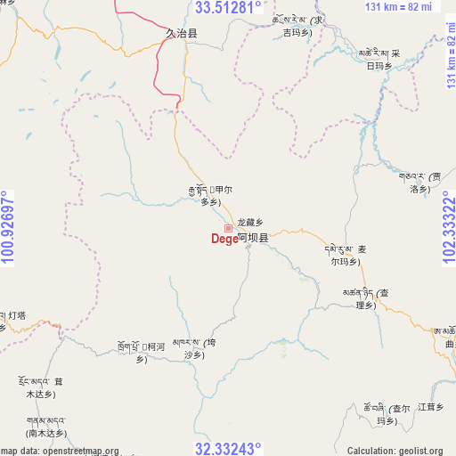
Dege GPS coordinates[2]
32° 55' 28.524" North, 101° 37' 48.324" East
| Map corner | latitude | longitude |
|---|---|---|
| Upper-left | 33.51281°, | 100.92697° |
| Center: | 32.92459°, | 101.63009° |
| Lower-right: | 32.33243°, | 102.33322° |
| Map W x H: | 131.2×131.2 km | = 81.5×81.5mi |
| max Lat: | 53.31946° ⇑34.3% North |
| Dege: | 32.92459° |
| min Lat: | ⇓65.7% South 18.22056° |
| min Long | Dege | max Long |
| 75.07348° | 101.63009° | 134.28917° |
| W 6.7%⇐ | ⇒93.3% E |
Elevation
Elevation of Dege is 3348 m = 10984 ft, and this is 2863.2 m = 9394 ft above average elevation for this country.
| Max E: |
5622 m = 18445 ft | 2.5% |
| Dege | 3348 m 10984 ft | |
| Avg. | 484.8 m = 1591 ft | |
Min E: |
-3 m = -10 ft | 97.5% |
See also: China elevation on elevation.city.
Geographical zone
Dege is located in North temperate zone (between Tropic of Cancer and the Arctic Circle). Distance of this Northern Tropic circle is 1055 km =655.5 mi to South.| Distance of | km | miles | from Dege |
|---|---|---|---|
| North Pole | 6346.2 | 3943.3 | to North |
| Arctic Circle | 3740.3 | 2324.1 | to North |
| Tropic Cancer | 1055 | 655.5 | to South |
| Equator | 3660.9 | 2274.8 | to South |


Nearby cities:
15 places around Dege: (largest is in red/bold)
• Aba
7.4 km =4.6 mi,  106°
106°
• Andou
11.5 km =7.1 mi,  317°
317°
• Cairima
67.4 km =41.9 mi,  46°
46°
• Gemo
8.7 km =5.4 mi,  344°
344°
• Hezhi
2 km =1.2 mi,  130°
130°
• Jia’erduo
11.1 km =6.9 mi,  332°
332°
• Kehe
43.3 km =26.9 mi,  211°
211°
• Kuasha
35.9 km =22.3 mi,  196°
196°
• Longcang
7 km =4.3 mi,  75°
75°
• Maikun
11.7 km =7.3 mi,  97°
97°
• Qihama
60.6 km =37.7 mi,  33°
33°
• Qiujima
59.5 km =37 mi,  359°
359°
• Rong’an
44.1 km =27.4 mi,  183°
183°
• Wa’erma
8.4 km =5.2 mi,  90°
90°
• Zhiqing Songduo
59.5 km =37 mi, 342°
Sources, notices
• [Note1] Compared only with cities in China existing in our database
• [Src1] Map data: © OpenStreetMap contributors (CC-BY-SA)
• [Src2] Other city data from geonames.org with taken over terms of usage.
• [Src3] Geographical zone / Annual Mean Temperature by Robert A. Rohde @ Wikipedia
