Zhangjiapan geodata
Zhangjiapan (Shaanxi) is a seat of a third-order administrative division; located in China in Asia/Shanghai (GMT+8) time zone. In our database, there are 1268 cities with bigger population. Compared to other cities in China, 80.4% of cities are located further ↓South; 77.2% of cities are located further →East and 89.7% of cities have lower elevation than Zhangjiapan. Note1


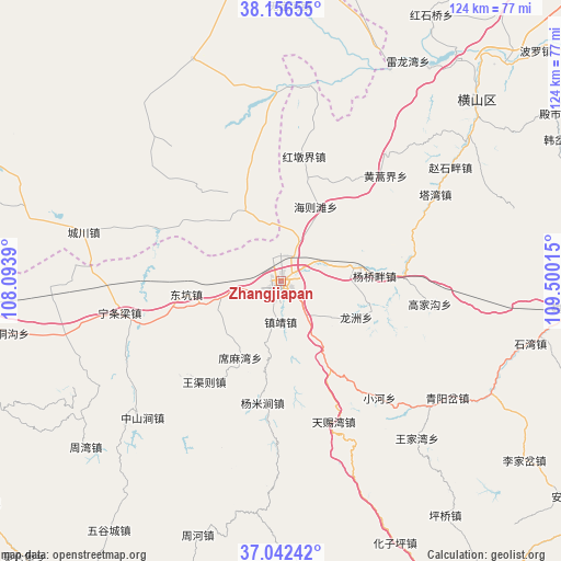
Zhangjiapan GPS coordinates[2]
37° 36' 5.652" North, 108° 47' 49.272" East
| Map corner | latitude | longitude |
|---|---|---|
| Upper-left | 38.15655°, | 108.0939° |
| Center: | 37.60157°, | 108.79702° |
| Lower-right: | 37.04242°, | 109.50015° |
| Map W x H: | 123.9×123.9 km | = 77×77mi |
| max Lat: | 53.31946° ⇑19.6% North |
| Zhangjiapan: | 37.60157° |
| min Lat: | ⇓80.4% South 18.22056° |
| min Long | Zhangjiapan | max Long |
| 75.07348° | 108.79702° | 134.28917° |
| W 22.8%⇐ | ⇒77.2% E |
Elevation
Elevation of Zhangjiapan is 1335 m = 4380 ft, and this is 850.2 m = 2789 ft above average elevation for this country.
| Max E: |
5622 m = 18445 ft | 10.3% |
| Zhangjiapan | 1335 m 4380 ft | |
| Avg. | 484.8 m = 1591 ft | |
Min E: |
-3 m = -10 ft | 89.7% |
See also: China elevation on elevation.city.
Geographical zone
Zhangjiapan is located in North temperate zone (between Tropic of Cancer and the Arctic Circle). Distance of this Northern Tropic circle is 1575 km =978.7 mi to South.| Distance of | km | miles | from Zhangjiapan |
|---|---|---|---|
| North Pole | 5826.2 | 3620.2 | to North |
| Arctic Circle | 3220.3 | 2001 | to North |
| Tropic Cancer | 1575 | 978.7 | to South |
| Equator | 4180.9 | 2597.9 | to South |


Nearby cities:
15 places around Zhangjiapan: (largest is in red/bold)
• Bao’an
86 km =53.4 mi,  182°
182°
• Dingbian
106 km =65.9 mi,  269°
269°
• Galutu
111.2 km =69.1 mi,  2°
2°
• Huai’an
142.6 km =88.6 mi,  217°
217°
• Huamachi
124.3 km =77.2 mi,  279°
279°
• Miaogou
111.8 km =69.5 mi, 224°
• Miaoxiang
139.3 km =86.6 mi,  211°
211°
• Oljoq
132.6 km =82.4 mi,  298°
298°
• Qiaochuan
136.6 km =84.9 mi,  226°
226°
• Rouyuan
146 km =90.7 mi, 209°
• Tiebiancheng
108 km =67.1 mi, 230°
• Wuqi
93.3 km =58 mi, 216°
• Xinzhai
104.9 km =65.2 mi, 225°
• Yuancheng
138.3 km =85.9 mi, 220°
• Yulinshi
112.7 km =70 mi,  47°
47°
Sources, notices
• [Note1] Compared only with cities in China existing in our database
• [Src1] Map data: © OpenStreetMap contributors (CC-BY-SA)
• [Src2] Other city data from geonames.org with taken over terms of usage.
• [Src3] Geographical zone / Annual Mean Temperature by Robert A. Rohde @ Wikipedia
