Galutu geodata
Galutu (Inner Mongolia) is a seat of a third-order administrative division; located in China in Asia/Shanghai (GMT+8) time zone. In our database, there are 1268 cities with bigger population. Compared to other cities in China, 82% of cities are located further ↓South; 77% of cities are located further →East and 89.4% of cities have lower elevation than Galutu. Note1


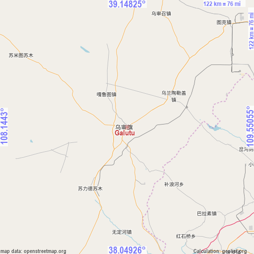
Galutu GPS coordinates[2]
38° 36' 3.096" North, 108° 50' 50.712" East
| Map corner | latitude | longitude |
|---|---|---|
| Upper-left | 39.14825°, | 108.1443° |
| Center: | 38.60086°, | 108.84742° |
| Lower-right: | 38.04926°, | 109.55055° |
| Map W x H: | 122.2×122.2 km | = 75.9×75.9mi |
| max Lat: | 53.31946° ⇑18% North |
| Galutu: | 38.60086° |
| min Lat: | ⇓82% South 18.22056° |
| min Long | Galutu | max Long |
| 75.07348° | 108.84742° | 134.28917° |
| W 23%⇐ | ⇒77% E |
Elevation
Elevation of Galutu is 1303 m = 4275 ft, and this is 818.2 m = 2684 ft above average elevation for this country.
| Max E: |
5622 m = 18445 ft | 10.6% |
| Galutu | 1303 m 4275 ft | |
| Avg. | 484.8 m = 1591 ft | |
Min E: |
-3 m = -10 ft | 89.4% |
See also: China elevation on elevation.city.
Geographical zone
Galutu is located in North temperate zone (between Tropic of Cancer and the Arctic Circle). Distance of this Northern Tropic circle is 1686.1 km =1047.7 mi to South.| Distance of | km | miles | from Galutu |
|---|---|---|---|
| North Pole | 5715 | 3551.1 | to North |
| Arctic Circle | 3109.2 | 1932 | to North |
| Tropic Cancer | 1686.1 | 1047.7 | to South |
| Equator | 4292 | 2666.9 | to South |


Nearby cities:
15 places around Galutu: (largest is in red/bold)
• Aletengxire
134.3 km =83.5 mi,  35°
35°
• Altan Xiret
133.8 km =83.1 mi, 35°
• Beijie
192.9 km =119.9 mi,  291°
291°
• Dingbian
156.8 km =97.4 mi,  224°
224°
• Dongsheng
166.5 km =103.5 mi, 35°
• Huamachi
155.4 km =96.6 mi,  234°
234°
• Lasengmiao
191.6 km =119.1 mi, 294°
• Oljoq
128.4 km =79.8 mi,  248°
248°
• Ordos
138 km =85.7 mi, 35°
• Shizuishan
193 km =119.9 mi, 291°
• Tianjiao
168.5 km =104.7 mi, 36°
• Ulan
93 km =57.8 mi,  306°
306°
• Xinli
138.6 km =86.1 mi,  355°
355°
• Yulinshi
84.8 km =52.7 mi,  113°
113°
• Zhangjiapan
111.2 km =69.1 mi,  182°
182°
Sources, notices
• [Note1] Compared only with cities in China existing in our database
• [Src1] Map data: © OpenStreetMap contributors (CC-BY-SA)
• [Src2] Other city data from geonames.org with taken over terms of usage.
• [Src3] Geographical zone / Annual Mean Temperature by Robert A. Rohde @ Wikipedia
