Yulinshi geodata
Yulinshi (Shaanxi) is a populated place; located in China in Asia/Shanghai (GMT+8) time zone. With population of 90,870 people, there are 467 cities with bigger population in this country. Compared to other cities in China, 81.4% of cities are located further ↓South; 72.6% of cities are located further →East and 86.2% of cities have lower elevation than Yulinshi. Note1


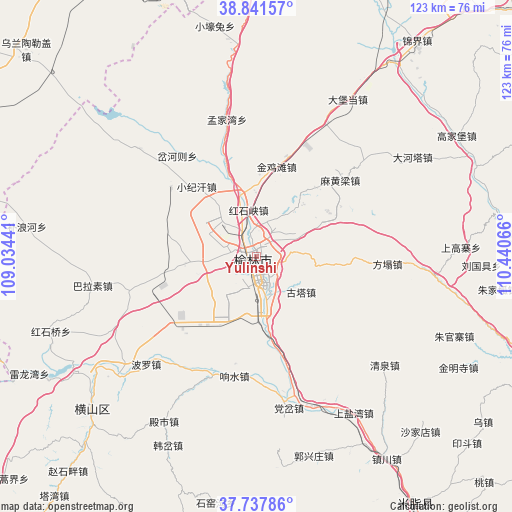
Yulinshi GPS coordinates[2]
38° 17' 30.516" North, 109° 44' 15.108" East
| Map corner | latitude | longitude |
|---|---|---|
| Upper-left | 38.84157°, | 109.03441° |
| Center: | 38.29181°, | 109.73753° |
| Lower-right: | 37.73786°, | 110.44066° |
| Map W x H: | 122.7×122.7 km | = 76.2×76.2mi |
| max Lat: | 53.31946° ⇑18.6% North |
| Yulinshi: | 38.29181° |
| min Lat: | ⇓81.4% South 18.22056° |
| min Long | Yulinshi | max Long |
| 75.07348° | 109.73753° | 134.28917° |
| W 27.4%⇐ | ⇒72.6% E |
Elevation
Elevation of Yulinshi is 1056 m = 3465 ft, and this is 571.2 m = 1874 ft above average elevation for this country.
| Max E: |
5622 m = 18445 ft | 13.8% |
| Yulinshi | 1056 m 3465 ft | |
| Avg. | 484.8 m = 1591 ft | |
Min E: |
-3 m = -10 ft | 86.2% |
See also: Yulinshi elevation on elevation.city.
Geographical zone
Yulinshi is located in North temperate zone (between Tropic of Cancer and the Arctic Circle). Distance of this Northern Tropic circle is 1651.7 km =1026.3 mi to South.| Distance of | km | miles | from Yulinshi |
|---|---|---|---|
| North Pole | 5749.4 | 3572.5 | to North |
| Arctic Circle | 3143.5 | 1953.3 | to North |
| Tropic Cancer | 1651.7 | 1026.3 | to South |
| Equator | 4257.7 | 2645.6 | to South |


Nearby cities:
15 places around Yulinshi: (largest is in red/bold)
• Aletengxire
143.2 km =89 mi,  0°
0°
• Altan Xiret
142.9 km =88.8 mi, 0°
• Dongcun
171.6 km =106.6 mi,  89°
89°
• Dongguan
145.1 km =90.2 mi,  56°
56°
• Dongsheng
170.7 km =106.1 mi,  6°
6°
• Galutu
84.8 km =52.7 mi,  293°
293°
• Gedong
140 km =87 mi,  108°
108°
• Lanyi
168.7 km =104.8 mi,  73°
73°
• Linquan
117.5 km =73 mi, 107°
• Lishi
149.9 km =93.1 mi,  125°
125°
• Liulin
138.3 km =85.9 mi, 132°
• Ningxiang
166.8 km =103.6 mi, 129°
• Ordos
146.5 km =91 mi, 1°
• Weifen
126.3 km =78.5 mi,  80°
80°
• Zhangjiapan
112.7 km =70 mi,  227°
227°
Sources, notices
• [Note1] Compared only with cities in China existing in our database
• [Src1] Map data: © OpenStreetMap contributors (CC-BY-SA)
• [Src2] Other city data from geonames.org with taken over terms of usage.
• [Src3] Geographical zone / Annual Mean Temperature by Robert A. Rohde @ Wikipedia
