Xinzha geodata
Xinzha (Hubei) is a seat of a fourth-order administrative division; located in China in Asia/Shanghai (GMT+8) time zone. In our database, there are 1268 cities with bigger population. Compared to other cities in China, 55.7% of cities are located further ↓South; 53.5% of cities are located further →East and 75.3% of cities have higher elevation than Xinzha. Note1


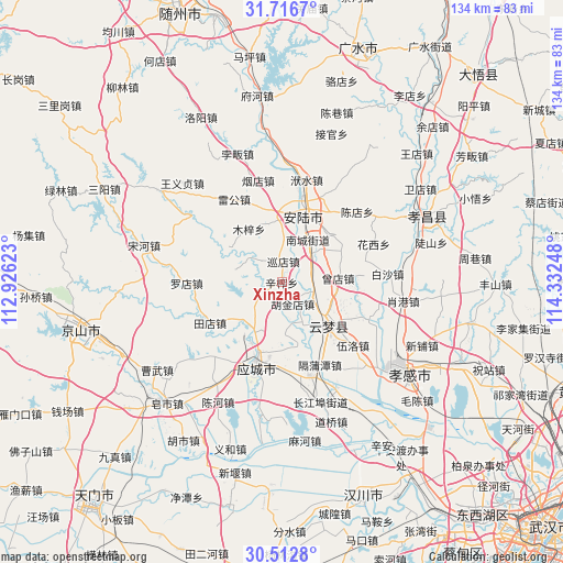
Xinzha GPS coordinates[2]
31° 6' 59.976" North, 113° 37' 45.66" East
| Map corner | latitude | longitude |
|---|---|---|
| Upper-left | 31.7167°, | 112.92623° |
| Center: | 31.11666°, | 113.62935° |
| Lower-right: | 30.5128°, | 114.33248° |
| Map W x H: | 133.9×133.9 km | = 83.2×83.2mi |
| max Lat: | 53.31946° ⇑44.3% North |
| Xinzha: | 31.11666° |
| min Lat: | ⇓55.7% South 18.22056° |
| min Long | Xinzha | max Long |
| 75.07348° | 113.62935° | 134.28917° |
| W 46.5%⇐ | ⇒53.5% E |
Elevation
Elevation of Xinzha is 36 m = 118 ft, and this is 448.8 m = 1472 ft below average elevation for this country.
| Max E: |
5622 m = 18445 ft | 75.3% |
| Avg. | 484.8 m = 1591 ft | |
| Xinzha | 36 m = 118 ft | |
Min E: |
-3 m = -10 ft | 24.7% |
See also: China elevation on elevation.city.
Geographical zone
Xinzha is located in North temperate zone (between Tropic of Cancer and the Arctic Circle). Distance of this Northern Tropic circle is 853.9 km =530.6 mi to South.| Distance of | km | miles | from Xinzha |
|---|---|---|---|
| North Pole | 6547.2 | 4068.2 | to North |
| Arctic Circle | 3941.3 | 2449 | to North |
| Tropic Cancer | 853.9 | 530.6 | to South |
| Equator | 3459.8 | 2149.8 | to South |


Nearby cities:
15 places around Xinzha: (largest is in red/bold)
• Anlu
16.3 km =10.1 mi,  16°
16°
• Chengbei
17.8 km =11.1 mi,  198°
198°
• Daodian
11.9 km =7.4 mi,  50°
50°
• Hujindian
5.6 km =3.5 mi,  150°
150°
• Lidian
16.5 km =10.3 mi, 47°
• Muzi
14.8 km =9.2 mi,  327°
327°
• Nancheng
12 km =7.5 mi,  32°
32°
• Qingminghe
10.7 km =6.6 mi, 147°
• Tangdi
14.2 km =8.8 mi,  343°
343°
• Wupu
18.4 km =11.4 mi,  117°
117°
• Xundian
5 km =3.1 mi,  4°
4°
• Yanghe
5.1 km =3.2 mi,  243°
243°
• Yitang
7.5 km =4.7 mi,  108°
108°
• Yunmeng Chengguanzhen
14.3 km =8.9 mi, 114°
• Zengdian
13.5 km =8.4 mi,  85°
85°
Sources, notices
• [Note1] Compared only with cities in China existing in our database
• [Src1] Map data: © OpenStreetMap contributors (CC-BY-SA)
• [Src2] Other city data from geonames.org with taken over terms of usage.
• [Src3] Geographical zone / Annual Mean Temperature by Robert A. Rohde @ Wikipedia
