Yulin geodata
Yulin (Guangxi) is a populated place; located in China in Asia/Shanghai (GMT+8) time zone. With population of 148,485 people, there are 300 cities with bigger population in this country. Compared to other cities in China, 95.9% of cities are located further ↑North; 70.6% of cities are located further →East and 62.9% of cities have higher elevation than Yulin. Note1


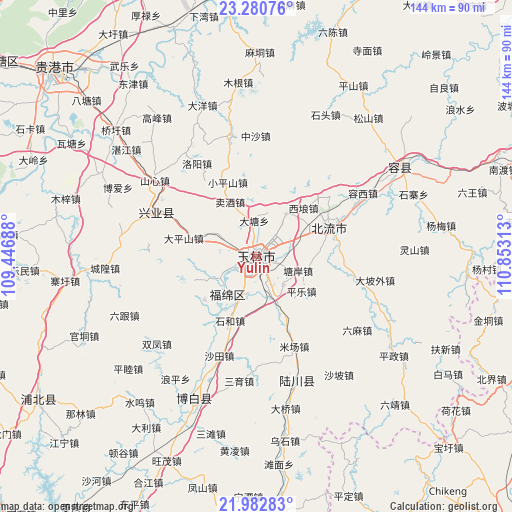
Yulin GPS coordinates[2]
22° 37' 59.988" North, 110° 9' 0" East
| Map corner | latitude | longitude |
|---|---|---|
| Upper-left | 23.28076°, | 109.44688° |
| Center: | 22.63333°, | 110.15° |
| Lower-right: | 21.98283°, | 110.85313° |
| Map W x H: | 144.3×144.3 km | = 89.7×89.7mi |
| max Lat: | 53.31946° ⇑95.9% North |
| Yulin: | 22.63333° |
| min Lat: | ⇓4.1% South 18.22056° |
| min Long | Yulin | max Long |
| 75.07348° | 110.15° | 134.28917° |
| W 29.4%⇐ | ⇒70.6% E |
Elevation
Elevation of Yulin is 83 m = 272 ft, and this is 401.8 m = 1318 ft below average elevation for this country.
| Max E: |
5622 m = 18445 ft | 62.9% |
| Avg. | 484.8 m = 1591 ft | |
| Yulin | 83 m = 272 ft | |
Min E: |
-3 m = -10 ft | 37.1% |
See also: Yulin elevation on elevation.city.
Geographical zone
Yulin is located in North Torrid zone (between Equator and Tropic of Cancer). Distance of this Northern Tropic circle is 89.3 km =55.5 mi to North.| Distance of | km | miles | from Yulin |
|---|---|---|---|
| North Pole | 7490.5 | 4654.4 | to North |
| Arctic Circle | 4884.6 | 3035.1 | to North |
| Tropic Cancer | 89.3 | 55.5 | to North |
| Equator | 2516.6 | 1563.7 | to South |


Nearby cities:
15 places around Yulin: (largest is in red/bold)
• Beijie
75.3 km =46.8 mi,  117°
117°
• Bobai
44.2 km =27.5 mi,  204°
204°
• Boyang
74.1 km =46 mi,  141°
141°
• Hehua
71.5 km =44.4 mi,  127°
127°
• Jindong
67.5 km =41.9 mi,  106°
106°
• Lingcheng
22 km =13.7 mi,  68°
68°
• Nandu
73.2 km =45.5 mi, 70°
• Pingding
73.6 km =45.7 mi,  159°
159°
• Qiaoxu
53.7 km =33.4 mi,  311°
311°
• Rongcheng
47.7 km =29.6 mi,  58°
58°
• Shinan
30.8 km =19.1 mi,  293°
293°
• Wenlou
66.2 km =41.1 mi, 155°
• Wenquan
35.9 km =22.3 mi, 162°
• Xiaojiang
73.4 km =45.6 mi,  236°
236°
• Yashan
53 km =32.9 mi, 203°
Sources, notices
• [Note1] Compared only with cities in China existing in our database
• [Src1] Map data: © OpenStreetMap contributors (CC-BY-SA)
• [Src2] Other city data from geonames.org with taken over terms of usage.
• [Src3] Geographical zone / Annual Mean Temperature by Robert A. Rohde @ Wikipedia
