Hehua geodata
Hehua (Guangdong) is a seat of a fourth-order administrative division; located in China in Asia/Urumqi (GMT+6) time zone. In our database, there are 1268 cities with bigger population. Compared to other cities in China, 96.9% of cities are located further ↑North; 68.3% of cities are located further →East and 64.8% of cities have higher elevation than Hehua. Note1


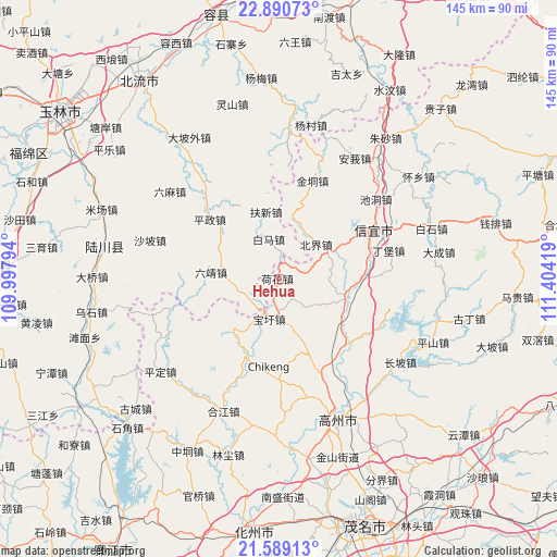
Hehua GPS coordinates[2]
22° 14' 29.184" North, 110° 42' 3.816" East
| Map corner | latitude | longitude |
|---|---|---|
| Upper-left | 22.89073°, | 109.99794° |
| Center: | 22.24144°, | 110.70106° |
| Lower-right: | 21.58913°, | 111.40419° |
| Map W x H: | 144.7×144.7 km | = 89.9×89.9mi |
| max Lat: | 53.31946° ⇑96.9% North |
| Hehua: | 22.24144° |
| min Lat: | ⇓3.1% South 18.22056° |
| min Long | Hehua | max Long |
| 75.07348° | 110.70106° | 134.28917° |
| W 31.7%⇐ | ⇒68.3% E |
Elevation
Elevation of Hehua is 74 m = 243 ft, and this is 410.8 m = 1348 ft below average elevation for this country.
| Max E: |
5622 m = 18445 ft | 64.8% |
| Avg. | 484.8 m = 1591 ft | |
| Hehua | 74 m = 243 ft | |
Min E: |
-3 m = -10 ft | 35.2% |
See also: China elevation on elevation.city.
Geographical zone
Hehua is located in North Torrid zone (between Equator and Tropic of Cancer). Distance of this Northern Tropic circle is 132.9 km =82.6 mi to North.| Distance of | km | miles | from Hehua |
|---|---|---|---|
| North Pole | 7534 | 4681.4 | to North |
| Arctic Circle | 4928.2 | 3062.2 | to North |
| Tropic Cancer | 132.9 | 82.6 | to North |
| Equator | 2473 | 1536.7 | to South |


Nearby cities:
15 places around Hehua: (largest is in red/bold)
• Baoxu
10.6 km =6.6 mi,  192°
192°
• Beijie
13.3 km =8.3 mi,  49°
49°
• Boyang
18.2 km =11.3 mi,  216°
216°
• Dajing
24.8 km =15.4 mi,  134°
134°
• Dingbao
28.9 km =18 mi,  76°
76°
• Dongzhen
28.9 km =18 mi,  57°
57°
• Dong’an
28.6 km =17.8 mi,  115°
115°
• Hetang
25.7 km =16 mi,  177°
177°
• Jindong
25.9 km =16.1 mi,  18°
18°
• Nantang
21.9 km =13.6 mi,  155°
155°
• Nawu
28.9 km =18 mi,  203°
203°
• Shiban
9.9 km =6.2 mi,  171°
171°
• Shuikou
21.9 km =13.6 mi,  87°
87°
• Tantou
17.3 km =10.7 mi,  111°
111°
• Zhenlong
18.1 km =11.2 mi,  100°
100°
Sources, notices
• [Note1] Compared only with cities in China existing in our database
• [Src1] Map data: © OpenStreetMap contributors (CC-BY-SA)
• [Src2] Other city data from geonames.org with taken over terms of usage.
• [Src3] Geographical zone / Annual Mean Temperature by Robert A. Rohde @ Wikipedia
