Dongmafang geodata
Dongmafang (Shanxi) is a seat of a fourth-order administrative division; located in China in Asia/Shanghai (GMT+8) time zone. In our database, there are 1268 cities with bigger population. Compared to other cities in China, 82.1% of cities are located further ↓South; 61% of cities are located further →East and 93.1% of cities have lower elevation than Dongmafang. Note1


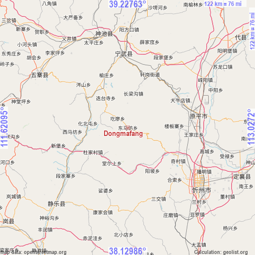
Dongmafang GPS coordinates[2]
38° 40' 51.06" North, 112° 19' 26.652" East
| Map corner | latitude | longitude |
|---|---|---|
| Upper-left | 39.22763°, | 111.62095° |
| Center: | 38.68085°, | 112.32407° |
| Lower-right: | 38.12986°, | 113.0272° |
| Map W x H: | 122.1×122.1 km | = 75.9×75.9mi |
| max Lat: | 53.31946° ⇑17.9% North |
| Dongmafang: | 38.68085° |
| min Lat: | ⇓82.1% South 18.22056° |
| min Long | Dongmafang | max Long |
| 75.07348° | 112.32407° | 134.28917° |
| W 39%⇐ | ⇒61% E |
Elevation
Elevation of Dongmafang is 1718 m = 5636 ft, and this is 1233.2 m = 4046 ft above average elevation for this country.
| Max E: |
5622 m = 18445 ft | 6.9% |
| Dongmafang | 1718 m 5636 ft | |
| Avg. | 484.8 m = 1591 ft | |
Min E: |
-3 m = -10 ft | 93.1% |
See also: China elevation on elevation.city.
Geographical zone
Dongmafang is located in North temperate zone (between Tropic of Cancer and the Arctic Circle). Distance of this Northern Tropic circle is 1695 km =1053.2 mi to South.| Distance of | km | miles | from Dongmafang |
|---|---|---|---|
| North Pole | 5706.2 | 3545.7 | to North |
| Arctic Circle | 3100.3 | 1926.4 | to North |
| Tropic Cancer | 1695 | 1053.2 | to South |
| Equator | 4300.9 | 2672.5 | to South |


Nearby cities:
15 places around Dongmafang: (largest is in red/bold)
• Dietaisi
17.4 km =10.8 mi,  322°
322°
• Dongzhai
24.2 km =15 mi,  305°
305°
• Echeng
45.8 km =28.5 mi,  221°
221°
• Fenghuang
35.3 km =21.9 mi,  356°
356°
• Huabeitun
19.5 km =12.1 mi,  275°
275°
• Huaidao
7.2 km =4.5 mi,  267°
267°
• Hubei
44.5 km =27.7 mi, 322°
• Longquan
46.3 km =28.8 mi,  345°
345°
• Shangyuzhuang
27.2 km =16.9 mi,  337°
337°
• Shijiazhuang
29.2 km =18.1 mi,  246°
246°
• Taipingzhuang
43.9 km =27.3 mi, 338°
• Ximafang
26.7 km =16.6 mi, 265°
• Xinbu
34.5 km =21.4 mi,  255°
255°
• Xuejiawa
42.3 km =26.3 mi,  14°
14°
• Yuanping
37.8 km =23.5 mi,  84°
84°
Sources, notices
• [Note1] Compared only with cities in China existing in our database
• [Src1] Map data: © OpenStreetMap contributors (CC-BY-SA)
• [Src2] Other city data from geonames.org with taken over terms of usage.
• [Src3] Geographical zone / Annual Mean Temperature by Robert A. Rohde @ Wikipedia
