Xinzhi geodata
Xinzhi (Shanxi) is a populated place; located in China in Asia/Shanghai (GMT+8) time zone. With population of 72,303 people, there are 594 cities with bigger population in this country. Compared to other cities in China, 78.2% of cities are located further ↓South; 64% of cities are located further →East and 74.9% of cities have lower elevation than Xinzhi. Note1


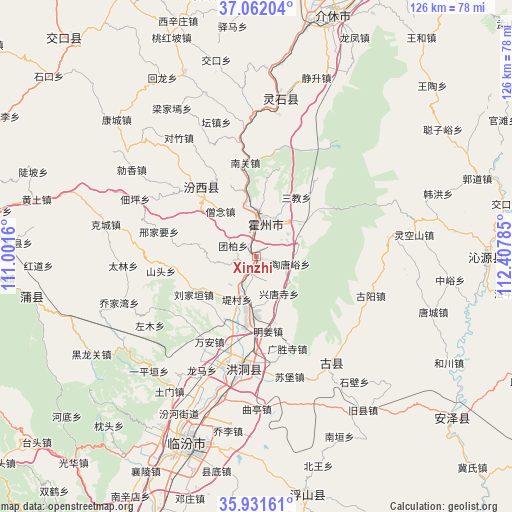
Xinzhi GPS coordinates[2]
36° 29' 56.004" North, 111° 42' 16.992" East
| Map corner | latitude | longitude |
|---|---|---|
| Upper-left | 37.06204°, | 111.0016° |
| Center: | 36.49889°, | 111.70472° |
| Lower-right: | 35.93161°, | 112.40785° |
| Map W x H: | 125.7×125.7 km | = 78.1×78.1mi |
| max Lat: | 53.31946° ⇑21.8% North |
| Xinzhi: | 36.49889° |
| min Lat: | ⇓78.2% South 18.22056° |
| min Long | Xinzhi | max Long |
| 75.07348° | 111.70472° | 134.28917° |
| W 36%⇐ | ⇒64% E |
Elevation
Elevation of Xinzhi is 519 m = 1703 ft, and this is 34.2 m = 112 ft above average elevation for this country.
| Max E: |
5622 m = 18445 ft | 25.1% |
| Xinzhi | 519 m 1703 ft | |
| Avg. | 484.8 m = 1591 ft | |
Min E: |
-3 m = -10 ft | 74.9% |
See also: Xinzhi elevation on elevation.city.
Geographical zone
Xinzhi is located in North temperate zone (between Tropic of Cancer and the Arctic Circle). Distance of this Northern Tropic circle is 1452.4 km =902.5 mi to South.| Distance of | km | miles | from Xinzhi |
|---|---|---|---|
| North Pole | 5948.8 | 3696.4 | to North |
| Arctic Circle | 3342.9 | 2077.2 | to North |
| Tropic Cancer | 1452.4 | 902.5 | to South |
| Equator | 4058.3 | 2521.7 | to South |


Nearby cities:
15 places around Xinzhi: (largest is in red/bold)
• Cuifeng
39.1 km =24.3 mi,  10°
10°
• Dadeng
66 km =41 mi,  193°
193°
• Dahuaishu
26.1 km =16.2 mi, 185°
• Dengzhuang
61.6 km =38.3 mi,  195°
195°
• Fucheng
61.5 km =38.2 mi,  129°
129°
• Jiexiu
61.3 km =38.1 mi,  17°
17°
• Linfen
48.5 km =30.1 mi, 200°
• Nanxindian
66.5 km =41.3 mi,  207°
207°
• Pucheng
55.3 km =34.4 mi,  260°
260°
• Qinhe
55.4 km =34.4 mi,  89°
89°
• Shuitou
68.8 km =42.8 mi,  320°
320°
• Tiantan
60.5 km =37.6 mi,  168°
168°
• Xiangling
59.1 km =36.7 mi, 207°
• Yong’an
21.5 km =13.4 mi,  325°
325°
• Yueyang
29.9 km =18.6 mi,  141°
141°
Sources, notices
• [Note1] Compared only with cities in China existing in our database
• [Src1] Map data: © OpenStreetMap contributors (CC-BY-SA)
• [Src2] Other city data from geonames.org with taken over terms of usage.
• [Src3] Geographical zone / Annual Mean Temperature by Robert A. Rohde @ Wikipedia
