Pucheng geodata
Pucheng (Shanxi) is a seat of a third-order administrative division; located in China in Asia/Shanghai (GMT+8) time zone. In our database, there are 1268 cities with bigger population. Compared to other cities in China, 78.1% of cities are located further ↓South; 66.7% of cities are located further →East and 84.6% of cities have lower elevation than Pucheng. Note1


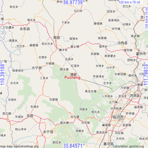
Pucheng GPS coordinates[2]
36° 24' 48.996" North, 111° 5' 42" East
| Map corner | latitude | longitude |
|---|---|---|
| Upper-left | 36.97739°, | 110.39188° |
| Center: | 36.41361°, | 111.095° |
| Lower-right: | 35.84571°, | 111.79813° |
| Map W x H: | 125.8×125.8 km | = 78.2×78.2mi |
| max Lat: | 53.31946° ⇑21.9% North |
| Pucheng: | 36.41361° |
| min Lat: | ⇓78.1% South 18.22056° |
| min Long | Pucheng | max Long |
| 75.07348° | 111.095° | 134.28917° |
| W 33.3%⇐ | ⇒66.7% E |
Elevation
Elevation of Pucheng is 958 m = 3143 ft, and this is 473.2 m = 1552 ft above average elevation for this country.
| Max E: |
5622 m = 18445 ft | 15.4% |
| Pucheng | 958 m 3143 ft | |
| Avg. | 484.8 m = 1591 ft | |
Min E: |
-3 m = -10 ft | 84.6% |
See also: China elevation on elevation.city.
Geographical zone
Pucheng is located in North temperate zone (between Tropic of Cancer and the Arctic Circle). Distance of this Northern Tropic circle is 1442.9 km =896.6 mi to South.| Distance of | km | miles | from Pucheng |
|---|---|---|---|
| North Pole | 5958.2 | 3702.3 | to North |
| Arctic Circle | 3352.4 | 2083.1 | to North |
| Tropic Cancer | 1442.9 | 896.6 | to South |
| Equator | 4048.8 | 2515.8 | to South |


Nearby cities:
15 places around Pucheng: (largest is in red/bold)
• Changning
54.1 km =33.6 mi,  206°
206°
• Dahuaishu
54.5 km =33.9 mi,  107°
107°
• Dengzhuang
63 km =39.1 mi,  142°
142°
• Gucheng
59.3 km =36.8 mi,  160°
160°
• Jichang
51.3 km =31.9 mi,  227°
227°
• Jingmao
63.6 km =39.5 mi, 158°
• Linfen
52.4 km =32.6 mi,  133°
133°
• Longquan
33.7 km =20.9 mi,  338°
338°
• Nanxindian
54.8 km =34.1 mi,  154°
154°
• Shuitou
63 km =39.1 mi,  9°
9°
• Xiangling
50.9 km =31.6 mi, 147°
• Xinshui
31.2 km =19.4 mi,  283°
283°
• Xinzhi
55.3 km =34.4 mi,  80°
80°
• Yong’an
50.1 km =31.1 mi,  57°
57°
• Zhihe
57.6 km =35.8 mi,  315°
315°
Sources, notices
• [Note1] Compared only with cities in China existing in our database
• [Src1] Map data: © OpenStreetMap contributors (CC-BY-SA)
• [Src2] Other city data from geonames.org with taken over terms of usage.
• [Src3] Geographical zone / Annual Mean Temperature by Robert A. Rohde @ Wikipedia
