Xiangling geodata
Xiangling (Shanxi) is a seat of a fourth-order administrative division; located in China in Asia/Shanghai (GMT+8) time zone. In our database, there are 1268 cities with bigger population. Compared to other cities in China, 77.3% of cities are located further ↓South; 65.5% of cities are located further →East and 70.9% of cities have lower elevation than Xiangling. Note1


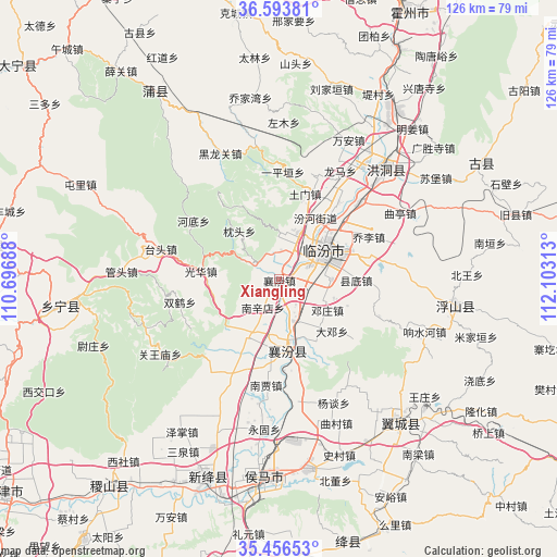
Xiangling GPS coordinates[2]
36° 1' 37.992" North, 111° 24' 0" East
| Map corner | latitude | longitude |
|---|---|---|
| Upper-left | 36.59381°, | 110.69688° |
| Center: | 36.02722°, | 111.4° |
| Lower-right: | 35.45653°, | 112.10313° |
| Map W x H: | 126.5×126.5 km | = 78.6×78.6mi |
| max Lat: | 53.31946° ⇑22.7% North |
| Xiangling: | 36.02722° |
| min Lat: | ⇓77.3% South 18.22056° |
| min Long | Xiangling | max Long |
| 75.07348° | 111.4° | 134.28917° |
| W 34.5%⇐ | ⇒65.5% E |
Elevation
Elevation of Xiangling is 428 m = 1404 ft, and this is 56.8 m = 186 ft below average elevation for this country.
| Max E: |
5622 m = 18445 ft | 29.1% |
| Avg. | 484.8 m = 1591 ft | |
| Xiangling | 428 m = 1404 ft | |
Min E: |
-3 m = -10 ft | 70.9% |
See also: China elevation on elevation.city.
Geographical zone
Xiangling is located in North temperate zone (between Tropic of Cancer and the Arctic Circle). Distance of this Northern Tropic circle is 1399.9 km =869.9 mi to South.| Distance of | km | miles | from Xiangling |
|---|---|---|---|
| North Pole | 6001.2 | 3729 | to North |
| Arctic Circle | 3395.3 | 2109.7 | to North |
| Tropic Cancer | 1399.9 | 869.9 | to South |
| Equator | 4005.9 | 2489.2 | to South |


Nearby cities:
15 places around Xiangling: (largest is in red/bold)
• Dadeng
16.8 km =10.4 mi,  134°
134°
• Dengzhuang
13 km =8.1 mi,  122°
122°
• Fencheng
25.9 km =16.1 mi,  205°
205°
• Gaoxian
34.3 km =21.3 mi,  176°
176°
• Gucheng
14.8 km =9.2 mi, 209°
• Jingmao
16.6 km =10.3 mi,  193°
193°
• Licun
30 km =18.6 mi,  170°
170°
• Linfen
12.7 km =7.9 mi,  57°
57°
• Nanjia
24.2 km =15 mi, 187°
• Nanxindian
7.4 km =4.6 mi, 209°
• Taosi
17 km =10.6 mi,  148°
148°
• Xijia
25.2 km =15.7 mi,  195°
195°
• Xincheng
17.2 km =10.7 mi, 169°
• Yangtan
30.7 km =19.1 mi,  156°
156°
• Yonggu
34.2 km =21.3 mi, 185°
Sources, notices
• [Note1] Compared only with cities in China existing in our database
• [Src1] Map data: © OpenStreetMap contributors (CC-BY-SA)
• [Src2] Other city data from geonames.org with taken over terms of usage.
• [Src3] Geographical zone / Annual Mean Temperature by Robert A. Rohde @ Wikipedia
