Yongbei geodata
Yongbei (Yunnan) is a seat of a third-order administrative division; located in China in Asia/Shanghai (GMT+8) time zone. In our database, there are 1268 cities with bigger population. Compared to other cities in China, 79.9% of cities are located further ↑North; 93.9% of cities are located further →East and 96% of cities have lower elevation than Yongbei. Note1


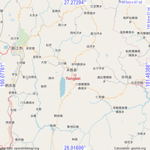
Yongbei GPS coordinates[2]
26° 38' 46.428" North, 100° 46' 50.628" East
| Map corner | latitude | longitude |
|---|---|---|
| Upper-left | 27.27294°, | 100.07761° |
| Center: | 26.64623°, | 100.78073° |
| Lower-right: | 26.01606°, | 101.48386° |
| Map W x H: | 139.8×139.8 km | = 86.9×86.9mi |
| max Lat: | 53.31946° ⇑79.9% North |
| Yongbei: | 26.64623° |
| min Lat: | ⇓20.1% South 18.22056° |
| min Long | Yongbei | max Long |
| 75.07348° | 100.78073° | 134.28917° |
| W 6.1%⇐ | ⇒93.9% E |
Elevation
Elevation of Yongbei is 2537 m = 8323 ft, and this is 2052.2 m = 6733 ft above average elevation for this country.
| Max E: |
5622 m = 18445 ft | 4% |
| Yongbei | 2537 m 8323 ft | |
| Avg. | 484.8 m = 1591 ft | |
Min E: |
-3 m = -10 ft | 96% |
See also: China elevation on elevation.city.
Geographical zone
Yongbei is located in North temperate zone (between Tropic of Cancer and the Arctic Circle). Distance of this Northern Tropic circle is 356.9 km =221.8 mi to South.| Distance of | km | miles | from Yongbei |
|---|---|---|---|
| North Pole | 7044.3 | 4377.1 | to North |
| Arctic Circle | 4438.4 | 2757.9 | to North |
| Tropic Cancer | 356.9 | 221.8 | to South |
| Equator | 2962.8 | 1841 | to South |


Nearby cities:
15 places around Yongbei: (largest is in red/bold)
• Dadukou
92.6 km =57.5 mi,  96°
96°
• Daxing
69.1 km =42.9 mi,  6°
6°
• Huangshan
59.3 km =36.8 mi,  289°
289°
• Jinhua
86.7 km =53.9 mi,  262°
262°
• Jinniu
96.3 km =59.8 mi,  192°
192°
• Lijiang
60.9 km =37.8 mi, 293°
• Panzhihua
92.9 km =57.7 mi,  94°
94°
• Qianjin
91.9 km =57.1 mi, 97°
• Renhe
96.6 km =60 mi, 99°
• Xiaqiaotou
94.5 km =58.7 mi,  309°
309°
• Xiqu
81.4 km =50.6 mi, 93°
• Yuhu
99.6 km =61.9 mi,  232°
232°
• Yunhe
59.5 km =37 mi, 256°
• Yuquan
81.6 km =50.7 mi, 93°
• Zhongxin
48.9 km =30.4 mi, 93°
Sources, notices
• [Note1] Compared only with cities in China existing in our database
• [Src1] Map data: © OpenStreetMap contributors (CC-BY-SA)
• [Src2] Other city data from geonames.org with taken over terms of usage.
• [Src3] Geographical zone / Annual Mean Temperature by Robert A. Rohde @ Wikipedia
