Yuhu geodata
Yuhu (Yunnan) is a seat of a third-order administrative division; located in China in Asia/Shanghai (GMT+8) time zone. In our database, there are 1268 cities with bigger population. Compared to other cities in China, 81.9% of cities are located further ↑North; 94.6% of cities are located further →East and 94.8% of cities have lower elevation than Yuhu. Note1


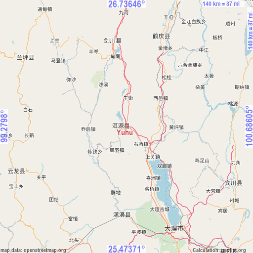
Yuhu GPS coordinates[2]
26° 6' 24.444" North, 99° 58' 58.512" East
| Map corner | latitude | longitude |
|---|---|---|
| Upper-left | 26.73646°, | 99.2798° |
| Center: | 26.10679°, | 99.98292° |
| Lower-right: | 25.47371°, | 100.68605° |
| Map W x H: | 140.4×140.4 km | = 87.2×87.2mi |
| max Lat: | 53.31946° ⇑81.9% North |
| Yuhu: | 26.10679° |
| min Lat: | ⇓18.1% South 18.22056° |
| min Long | Yuhu | max Long |
| 75.07348° | 99.98292° | 134.28917° |
| W 5.4%⇐ | ⇒94.6% E |
Elevation
Elevation of Yuhu is 2054 m = 6739 ft, and this is 1569.2 m = 5148 ft above average elevation for this country.
| Max E: |
5622 m = 18445 ft | 5.2% |
| Yuhu | 2054 m 6739 ft | |
| Avg. | 484.8 m = 1591 ft | |
Min E: |
-3 m = -10 ft | 94.8% |
See also: China elevation on elevation.city.
Geographical zone
Yuhu is located in North temperate zone (between Tropic of Cancer and the Arctic Circle). Distance of this Northern Tropic circle is 296.9 km =184.5 mi to South.| Distance of | km | miles | from Yuhu |
|---|---|---|---|
| North Pole | 7104.3 | 4414.4 | to North |
| Arctic Circle | 4498.4 | 2795.2 | to North |
| Tropic Cancer | 296.9 | 184.5 | to South |
| Equator | 2902.8 | 1803.7 | to South |


Nearby cities:
15 places around Yuhu: (largest is in red/bold)
• Dali
62.4 km =38.8 mi,  158°
158°
• Huangshan
83.4 km =51.8 mi,  16°
16°
• Jinding
65.5 km =40.7 mi,  304°
304°
• Jinhua
48.4 km =30.1 mi,  352°
352°
• Jinniu
68.2 km =42.4 mi,  119°
119°
• Laojie
84.8 km =52.7 mi,  210°
210°
• Lijiang
88 km =54.7 mi, 15°
• Luzhang
116.8 km =72.6 mi,  262°
262°
• Micheng
101.6 km =63.1 mi,  149°
149°
• Nanzhao
103.5 km =64.3 mi, 161°
• Shangjie
48.4 km =30.1 mi,  180°
180°
• Shimen
60.1 km =37.3 mi,  246°
246°
• Xiangcheng
91.8 km =57 mi,  140°
140°
• Yongbei
99.6 km =61.9 mi,  52°
52°
• Yunhe
51.2 km =31.8 mi, 24°
Sources, notices
• [Note1] Compared only with cities in China existing in our database
• [Src1] Map data: © OpenStreetMap contributors (CC-BY-SA)
• [Src2] Other city data from geonames.org with taken over terms of usage.
• [Src3] Geographical zone / Annual Mean Temperature by Robert A. Rohde @ Wikipedia
