Lijiang geodata
Lijiang (Yunnan) is a populated place; located in China in Asia/Shanghai (GMT+8) time zone. With population of 1,137,600 people, there are 59 cities with bigger population in this country. Compared to other cities in China, 79.1% of cities are located further ↑North; 94.4% of cities are located further →East and 95.7% of cities have lower elevation than Lijiang. Note1


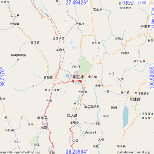
Lijiang GPS coordinates[2]
26° 52' 7.644" North, 100° 13' 14.592" East
| Map corner | latitude | longitude |
|---|---|---|
| Upper-left | 27.49426°, | 99.5176° |
| Center: | 26.86879°, | 100.22072° |
| Lower-right: | 26.23984°, | 100.92385° |
| Map W x H: | 139.5×139.5 km | = 86.7×86.7mi |
| max Lat: | 53.31946° ⇑79.1% North |
| Lijiang: | 26.86879° |
| min Lat: | ⇓20.9% South 18.22056° |
| min Long | Lijiang | max Long |
| 75.07348° | 100.22072° | 134.28917° |
| W 5.6%⇐ | ⇒94.4% E |
Elevation
Elevation of Lijiang is 2397 m = 7864 ft, and this is 1912.2 m = 6274 ft above average elevation for this country.
| Max E: |
5622 m = 18445 ft | 4.3% |
| Lijiang | 2397 m 7864 ft | |
| Avg. | 484.8 m = 1591 ft | |
Min E: |
-3 m = -10 ft | 95.7% |
See also: Lijiang elevation on elevation.city.
Geographical zone
Lijiang is located in North temperate zone (between Tropic of Cancer and the Arctic Circle). Distance of this Northern Tropic circle is 381.6 km =237.1 mi to South.| Distance of | km | miles | from Lijiang |
|---|---|---|---|
| North Pole | 7019.5 | 4361.7 | to North |
| Arctic Circle | 4413.6 | 2742.5 | to North |
| Tropic Cancer | 381.6 | 237.1 | to South |
| Equator | 2987.5 | 1856.3 | to South |


Nearby cities:
15 places around Lijiang: (largest is in red/bold)
• Baohe
95.9 km =59.6 mi,  292°
292°
• Daxing
77.4 km =48.1 mi,  55°
55°
• Geluwan
79.2 km =49.2 mi,  315°
315°
• Huangshan
4.7 km =2.9 mi,  181°
181°
• Jinding
91.1 km =56.6 mi,  238°
238°
• Jinhua
47.6 km =29.6 mi,  219°
219°
• Kaiwen
49.8 km =30.9 mi,  309°
309°
• Shuijia
70.6 km =43.9 mi,  347°
347°
• Wujing
114.7 km =71.3 mi, 323°
• Xiaqiaotou
39.3 km =24.4 mi,  333°
333°
• Yongbei
60.9 km =37.8 mi,  113°
113°
• Yuhu
88 km =54.7 mi,  195°
195°
• Yunhe
38.3 km =23.8 mi, 183°
• Zhongcun
103.3 km =64.2 mi,  359°
359°
• Zhongxin
108 km =67.1 mi, 105°
Sources, notices
• [Note1] Compared only with cities in China existing in our database
• [Src1] Map data: © OpenStreetMap contributors (CC-BY-SA)
• [Src2] Other city data from geonames.org with taken over terms of usage.
• [Src3] Geographical zone / Annual Mean Temperature by Robert A. Rohde @ Wikipedia
