Huangshan geodata
Huangshan (Yunnan) is a seat of a third-order administrative division; located in China in Asia/Shanghai (GMT+8) time zone. In our database, there are 1268 cities with bigger population. Compared to other cities in China, 79.3% of cities are located further ↑North; 94.4% of cities are located further →East and 95.6% of cities have lower elevation than Huangshan. Note1


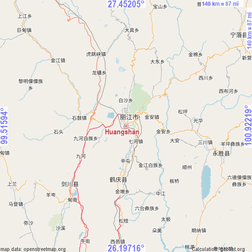
Huangshan GPS coordinates[2]
26° 49' 34.824" North, 100° 13' 8.616" East
| Map corner | latitude | longitude |
|---|---|---|
| Upper-left | 27.45205°, | 99.51594° |
| Center: | 26.82634°, | 100.21906° |
| Lower-right: | 26.19716°, | 100.92219° |
| Map W x H: | 139.5×139.5 km | = 86.7×86.7mi |
| max Lat: | 53.31946° ⇑79.3% North |
| Huangshan: | 26.82634° |
| min Lat: | ⇓20.7% South 18.22056° |
| min Long | Huangshan | max Long |
| 75.07348° | 100.21906° | 134.28917° |
| W 5.6%⇐ | ⇒94.4% E |
Elevation
Elevation of Huangshan is 2378 m = 7802 ft, and this is 1893.2 m = 6211 ft above average elevation for this country.
| Max E: |
5622 m = 18445 ft | 4.4% |
| Huangshan | 2378 m 7802 ft | |
| Avg. | 484.8 m = 1591 ft | |
Min E: |
-3 m = -10 ft | 95.6% |
See also: China elevation on elevation.city.
Geographical zone
Huangshan is located in North temperate zone (between Tropic of Cancer and the Arctic Circle). Distance of this Northern Tropic circle is 376.9 km =234.2 mi to South.| Distance of | km | miles | from Huangshan |
|---|---|---|---|
| North Pole | 7024.3 | 4364.7 | to North |
| Arctic Circle | 4418.4 | 2745.5 | to North |
| Tropic Cancer | 376.9 | 234.2 | to South |
| Equator | 2982.8 | 1853.4 | to South |


Nearby cities:
15 places around Huangshan: (largest is in red/bold)
• Baohe
97.6 km =60.6 mi,  294°
294°
• Daxing
80.3 km =49.9 mi,  52°
52°
• Geluwan
82.5 km =51.3 mi,  317°
317°
• Jinding
88.5 km =55 mi,  240°
240°
• Jinhua
43.9 km =27.3 mi,  223°
223°
• Kaiwen
52.9 km =32.9 mi,  313°
313°
• Lijiang
4.7 km =2.9 mi,  1°
1°
• Shuijia
75.2 km =46.7 mi,  348°
348°
• Wujing
118.4 km =73.6 mi,  325°
325°
• Xiaqiaotou
43.5 km =27 mi,  336°
336°
• Yongbei
59.3 km =36.8 mi,  109°
109°
• Yuhu
83.4 km =51.8 mi,  196°
196°
• Yunhe
33.6 km =20.9 mi,  183°
183°
• Zhongcun
108.1 km =67.2 mi,  359°
359°
• Zhongxin
107.1 km =66.5 mi,  102°
102°
Sources, notices
• [Note1] Compared only with cities in China existing in our database
• [Src1] Map data: © OpenStreetMap contributors (CC-BY-SA)
• [Src2] Other city data from geonames.org with taken over terms of usage.
• [Src3] Geographical zone / Annual Mean Temperature by Robert A. Rohde @ Wikipedia
