Yunhe geodata
Yunhe (Yunnan) is a seat of a third-order administrative division; located in China in Asia/Shanghai (GMT+8) time zone. In our database, there are 1268 cities with bigger population. Compared to other cities in China, 80.4% of cities are located further ↑North; 94.4% of cities are located further →East and 95.2% of cities have lower elevation than Yunhe. Note1


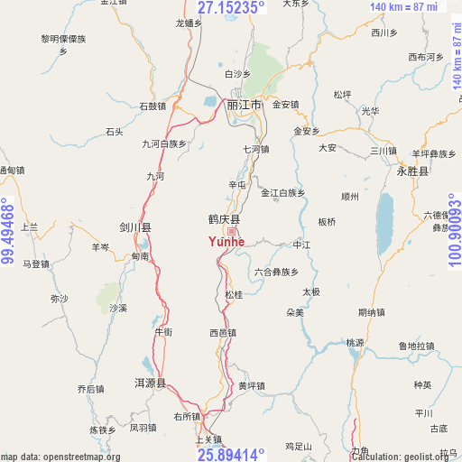
Yunhe GPS coordinates[2]
26° 31' 29.892" North, 100° 11' 52.08" East
| Map corner | latitude | longitude |
|---|---|---|
| Upper-left | 27.15235°, | 99.49468° |
| Center: | 26.52497°, | 100.1978° |
| Lower-right: | 25.89414°, | 100.90093° |
| Map W x H: | 139.9×139.9 km | = 86.9×86.9mi |
| max Lat: | 53.31946° ⇑80.4% North |
| Yunhe: | 26.52497° |
| min Lat: | ⇓19.6% South 18.22056° |
| min Long | Yunhe | max Long |
| 75.07348° | 100.1978° | 134.28917° |
| W 5.6%⇐ | ⇒94.4% E |
Elevation
Elevation of Yunhe is 2195 m = 7201 ft, and this is 1710.2 m = 5611 ft above average elevation for this country.
| Max E: |
5622 m = 18445 ft | 4.8% |
| Yunhe | 2195 m 7201 ft | |
| Avg. | 484.8 m = 1591 ft | |
Min E: |
-3 m = -10 ft | 95.2% |
See also: China elevation on elevation.city.
Geographical zone
Yunhe is located in North temperate zone (between Tropic of Cancer and the Arctic Circle). Distance of this Northern Tropic circle is 343.4 km =213.4 mi to South.| Distance of | km | miles | from Yunhe |
|---|---|---|---|
| North Pole | 7057.8 | 4385.5 | to North |
| Arctic Circle | 4451.9 | 2766.3 | to North |
| Tropic Cancer | 343.4 | 213.4 | to South |
| Equator | 2949.3 | 1832.6 | to South |


Nearby cities:
15 places around Yunhe: (largest is in red/bold)
• Dali
104.6 km =65 mi,  179°
179°
• Daxing
105.4 km =65.5 mi,  38°
38°
• Huangshan
33.6 km =20.9 mi,  3°
3°
• Jinding
76 km =47.2 mi,  262°
262°
• Jinhua
28 km =17.4 mi,  272°
272°
• Jinniu
88.9 km =55.2 mi,  154°
154°
• Kaiwen
78.9 km =49 mi,  332°
332°
• Lijiang
38.3 km =23.8 mi, 3°
• Shangjie
97.4 km =60.5 mi,  192°
192°
• Shimen
103.9 km =64.6 mi,  227°
227°
• Shuijia
107.9 km =67 mi,  352°
352°
• Xiaqiaotou
75 km =46.6 mi, 348°
• Yongbei
59.5 km =37 mi,  76°
76°
• Yuhu
51.2 km =31.8 mi,  204°
204°
• Zhongxin
107.3 km =66.7 mi, 84°
Sources, notices
• [Note1] Compared only with cities in China existing in our database
• [Src1] Map data: © OpenStreetMap contributors (CC-BY-SA)
• [Src2] Other city data from geonames.org with taken over terms of usage.
• [Src3] Geographical zone / Annual Mean Temperature by Robert A. Rohde @ Wikipedia
