Zhongxiang geodata
Zhongxiang (Hubei) is a populated place; located in China in Asia/Shanghai (GMT+8) time zone. With population of 108,883 people, there are 403 cities with bigger population in this country. Compared to other cities in China, 56% of cities are located further ↓South; 59.6% of cities are located further →East and 70.5% of cities have higher elevation than Zhongxiang. Note1


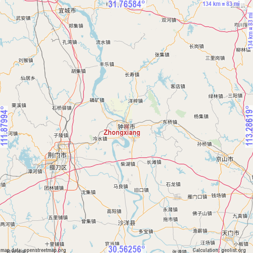
Zhongxiang GPS coordinates[2]
31° 9' 57.996" North, 112° 34' 59.016" East
| Map corner | latitude | longitude |
|---|---|---|
| Upper-left | 31.76584°, | 111.87994° |
| Center: | 31.16611°, | 112.58306° |
| Lower-right: | 30.56256°, | 113.28619° |
| Map W x H: | 133.8×133.8 km | = 83.1×83.1mi |
| max Lat: | 53.31946° ⇑44% North |
| Zhongxiang: | 31.16611° |
| min Lat: | ⇓56% South 18.22056° |
| min Long | Zhongxiang | max Long |
| 75.07348° | 112.58306° | 134.28917° |
| W 40.4%⇐ | ⇒59.6% E |
Elevation
Elevation of Zhongxiang is 50 m = 164 ft, and this is 434.8 m = 1427 ft below average elevation for this country.
| Max E: |
5622 m = 18445 ft | 70.5% |
| Avg. | 484.8 m = 1591 ft | |
| Zhongxiang | 50 m = 164 ft | |
Min E: |
-3 m = -10 ft | 29.5% |
See also: Zhongxiang elevation on elevation.city.
Geographical zone
Zhongxiang is located in North temperate zone (between Tropic of Cancer and the Arctic Circle). Distance of this Northern Tropic circle is 859.4 km =534 mi to South.| Distance of | km | miles | from Zhongxiang |
|---|---|---|---|
| North Pole | 6541.7 | 4064.8 | to North |
| Arctic Circle | 3935.8 | 2445.6 | to North |
| Tropic Cancer | 859.4 | 534 | to South |
| Equator | 3465.3 | 2153.2 | to South |


Nearby cities:
15 places around Zhongxiang: (largest is in red/bold)
• Chaihu
19.4 km =12.1 mi,  177°
177°
• Changshou
28 km =17.4 mi,  5°
5°
• Changtan
23.2 km =14.4 mi,  141°
141°
• Dongqiao
23.8 km =14.8 mi,  82°
82°
• Jiukou
34.5 km =21.4 mi,  166°
166°
• Kedian
34.6 km =21.5 mi,  51°
51°
• Lengshui
15.3 km =9.5 mi,  246°
246°
• Linkuang
21.2 km =13.2 mi,  312°
312°
• Maliang
31.4 km =19.5 mi,  186°
186°
• Pailou
31.2 km =19.4 mi, 246°
• Shipai
21.5 km =13.4 mi,  201°
201°
• Shuanghe
32.3 km =20.1 mi,  293°
293°
• Wenji
5.2 km =3.2 mi,  261°
261°
• Yangzi
14.8 km =9.2 mi,  18°
18°
• Zilingpu
34.9 km =21.7 mi, 263°
Sources, notices
• [Note1] Compared only with cities in China existing in our database
• [Src1] Map data: © OpenStreetMap contributors (CC-BY-SA)
• [Src2] Other city data from geonames.org with taken over terms of usage.
• [Src3] Geographical zone / Annual Mean Temperature by Robert A. Rohde @ Wikipedia
