Kedian geodata
Kedian (Hubei) is a seat of a fourth-order administrative division; located in China in Asia/Shanghai (GMT+8) time zone. In our database, there are 1268 cities with bigger population. Compared to other cities in China, 57.5% of cities are located further ↓South; 58.3% of cities are located further →East and 56.9% of cities have higher elevation than Kedian. Note1


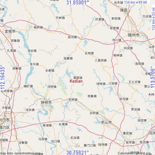
Kedian GPS coordinates[2]
31° 21' 37.908" North, 112° 52' 2.892" East
| Map corner | latitude | longitude |
|---|---|---|
| Upper-left | 31.95901°, | 112.16435° |
| Center: | 31.36053°, | 112.86747° |
| Lower-right: | 30.75821°, | 113.5706° |
| Map W x H: | 133.5×133.5 km | = 83×83mi |
| max Lat: | 53.31946° ⇑42.5% North |
| Kedian: | 31.36053° |
| min Lat: | ⇓57.5% South 18.22056° |
| min Long | Kedian | max Long |
| 75.07348° | 112.86747° | 134.28917° |
| W 41.7%⇐ | ⇒58.3% E |
Elevation
Elevation of Kedian is 118 m = 387 ft, and this is 366.8 m = 1203 ft below average elevation for this country.
| Max E: |
5622 m = 18445 ft | 56.9% |
| Avg. | 484.8 m = 1591 ft | |
| Kedian | 118 m = 387 ft | |
Min E: |
-3 m = -10 ft | 43.1% |
See also: China elevation on elevation.city.
Geographical zone
Kedian is located in North temperate zone (between Tropic of Cancer and the Arctic Circle). Distance of this Northern Tropic circle is 881 km =547.4 mi to South.| Distance of | km | miles | from Kedian |
|---|---|---|---|
| North Pole | 6520.1 | 4051.4 | to North |
| Arctic Circle | 3914.2 | 2432.2 | to North |
| Tropic Cancer | 881 | 547.4 | to South |
| Equator | 3487 | 2166.7 | to South |


Nearby cities:
15 places around Kedian: (largest is in red/bold)
• Changgang
23.5 km =14.6 mi,  25°
25°
• Changshou
24.9 km =15.5 mi,  284°
284°
• Dongqiao
18.9 km =11.7 mi,  190°
190°
• Fengle
39.2 km =24.4 mi,  287°
287°
• Liulin
39.9 km =24.8 mi,  60°
60°
• Lülin
20.6 km =12.8 mi,  104°
104°
• Sanligang
24.5 km =15.2 mi,  52°
52°
• Sanyang
30.5 km =19 mi, 99°
• Shuanghe
35.3 km =21.9 mi,  351°
351°
• Sunqiao
33.5 km =20.8 mi,  155°
155°
• Wenji
39.2 km =24.4 mi,  235°
235°
• Yangji
19.9 km =12.4 mi,  142°
142°
• Yangzi
23.6 km =14.7 mi,  251°
251°
• Zhangji
18.8 km =11.7 mi,  333°
333°
• Zhongxiang
34.6 km =21.5 mi,  231°
231°
Sources, notices
• [Note1] Compared only with cities in China existing in our database
• [Src1] Map data: © OpenStreetMap contributors (CC-BY-SA)
• [Src2] Other city data from geonames.org with taken over terms of usage.
• [Src3] Geographical zone / Annual Mean Temperature by Robert A. Rohde @ Wikipedia
