Changtan geodata
Changtan (Hubei) is a seat of a fourth-order administrative division; located in China in Asia/Shanghai (GMT+8) time zone. In our database, there are 1268 cities with bigger population. Compared to other cities in China, 54.9% of cities are located further ↓South; 59% of cities are located further →East and 72.3% of cities have higher elevation than Changtan. Note1


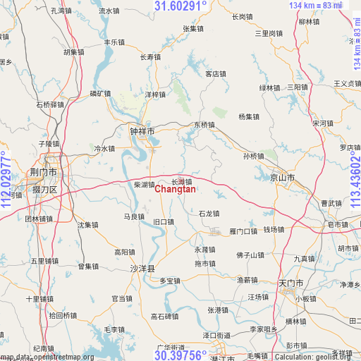
Changtan GPS coordinates[2]
31° 0' 7.704" North, 112° 43' 58.404" East
| Map corner | latitude | longitude |
|---|---|---|
| Upper-left | 31.60291°, | 112.02977° |
| Center: | 31.00214°, | 112.73289° |
| Lower-right: | 30.39756°, | 113.43602° |
| Map W x H: | 134×134 km | = 83.3×83.3mi |
| max Lat: | 53.31946° ⇑45.1% North |
| Changtan: | 31.00214° |
| min Lat: | ⇓54.9% South 18.22056° |
| min Long | Changtan | max Long |
| 75.07348° | 112.73289° | 134.28917° |
| W 41%⇐ | ⇒59% E |
Elevation
Elevation of Changtan is 44 m = 144 ft, and this is 440.8 m = 1446 ft below average elevation for this country.
| Max E: |
5622 m = 18445 ft | 72.3% |
| Avg. | 484.8 m = 1591 ft | |
| Changtan | 44 m = 144 ft | |
Min E: |
-3 m = -10 ft | 27.7% |
See also: China elevation on elevation.city.
Geographical zone
Changtan is located in North temperate zone (between Tropic of Cancer and the Arctic Circle). Distance of this Northern Tropic circle is 841.2 km =522.7 mi to South.| Distance of | km | miles | from Changtan |
|---|---|---|---|
| North Pole | 6559.9 | 4076.1 | to North |
| Arctic Circle | 3954.1 | 2457 | to North |
| Tropic Cancer | 841.2 | 522.7 | to South |
| Equator | 3447.1 | 2141.9 | to South |


Nearby cities:
15 places around Changtan: (largest is in red/bold)
• Chaihu
13.6 km =8.5 mi,  265°
265°
• Dongqiao
23.2 km =14.4 mi,  23°
23°
• Gaoyang
33.6 km =20.9 mi,  218°
218°
• Jiukou
16.6 km =10.3 mi,  202°
202°
• Lengshui
30.9 km =19.2 mi,  293°
293°
• Maliang
21.9 km =13.6 mi,  233°
233°
• Shilong
15.8 km =9.8 mi,  138°
138°
• Shipai
22.2 km =13.8 mi, 265°
• Sunqiao
28.4 km =17.6 mi,  70°
70°
• Tuoshi
31.8 km =19.8 mi,  163°
163°
• Wenji
26.1 km =16.2 mi,  311°
311°
• Yangji
34.7 km =21.6 mi,  45°
45°
• Yangzi
33.6 km =20.9 mi,  343°
343°
• Yanmenkou
29.6 km =18.4 mi,  128°
128°
• Zhongxiang
23.2 km =14.4 mi,  321°
321°
Sources, notices
• [Note1] Compared only with cities in China existing in our database
• [Src1] Map data: © OpenStreetMap contributors (CC-BY-SA)
• [Src2] Other city data from geonames.org with taken over terms of usage.
• [Src3] Geographical zone / Annual Mean Temperature by Robert A. Rohde @ Wikipedia
