Anling geodata
Anling (Henan) is a seat of a third-order administrative division; located in China in Asia/Shanghai (GMT+8) time zone. In our database, there are 1268 cities with bigger population. Compared to other cities in China, 70.7% of cities are located further ↓South; 50.3% of cities are located further →East and 67.6% of cities have higher elevation than Anling. Note1


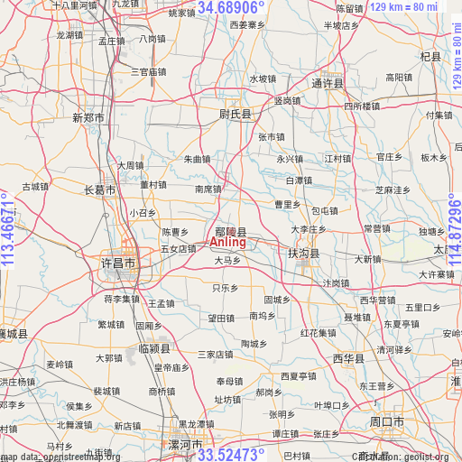
Anling GPS coordinates[2]
34° 6' 32.04" North, 114° 10' 11.388" East
| Map corner | latitude | longitude |
|---|---|---|
| Upper-left | 34.68906°, | 113.46671° |
| Center: | 34.1089°, | 114.16983° |
| Lower-right: | 33.52473°, | 114.87296° |
| Map W x H: | 129.5×129.5 km | = 80.5×80.5mi |
| max Lat: | 53.31946° ⇑29.3% North |
| Anling: | 34.1089° |
| min Lat: | ⇓70.7% South 18.22056° |
| min Long | Anling | max Long |
| 75.07348° | 114.16983° | 134.28917° |
| W 49.7%⇐ | ⇒50.3% E |
Elevation
Elevation of Anling is 62 m = 203 ft, and this is 422.8 m = 1387 ft below average elevation for this country.
| Max E: |
5622 m = 18445 ft | 67.6% |
| Avg. | 484.8 m = 1591 ft | |
| Anling | 62 m = 203 ft | |
Min E: |
-3 m = -10 ft | 32.4% |
See also: China elevation on elevation.city.
Geographical zone
Anling is located in North temperate zone (between Tropic of Cancer and the Arctic Circle). Distance of this Northern Tropic circle is 1186.6 km =737.3 mi to South.| Distance of | km | miles | from Anling |
|---|---|---|---|
| North Pole | 6214.5 | 3861.5 | to North |
| Arctic Circle | 3608.6 | 2242.3 | to North |
| Tropic Cancer | 1186.6 | 737.3 | to South |
| Equator | 3792.6 | 2356.6 | to South |


Nearby cities:
15 places around Anling: (largest is in red/bold)
• Duqu
43.4 km =27 mi,  220°
220°
• Fugou Chengguanzhen
20.2 km =12.6 mi,  103°
103°
• Guxiang
34.9 km =21.7 mi, 221°
• Huangdimiao
41.6 km =25.8 mi,  204°
204°
• Jiangguanchi
30.2 km =18.8 mi,  246°
246°
• Jiangliji
36.1 km =22.4 mi,  238°
238°
• Jianshe
38.8 km =24.1 mi,  288°
288°
• Juling
33.6 km =20.9 mi, 215°
• Shenjian
45.7 km =28.4 mi,  257°
257°
• Shiqiao
32.3 km =20.1 mi,  230°
230°
• Taichen
44.1 km =27.4 mi,  211°
211°
• Wangmeng
28.2 km =17.5 mi, 224°
• Weishi Chengguanzhen
33.9 km =21.1 mi,  2°
2°
• Xuchang
29.5 km =18.3 mi, 253°
• Zhangpan
21 km =13 mi, 231°
Sources, notices
• [Note1] Compared only with cities in China existing in our database
• [Src1] Map data: © OpenStreetMap contributors (CC-BY-SA)
• [Src2] Other city data from geonames.org with taken over terms of usage.
• [Src3] Geographical zone / Annual Mean Temperature by Robert A. Rohde @ Wikipedia
