Baoshan geodata
Baoshan (Shanghai) is a seat of a third-order administrative division; located in China in Asia/Shanghai (GMT+8) time zone. In our database, there are 1268 cities with bigger population. Compared to other cities in China, 57.8% of cities are located further ↓South; 90% of cities are located further ←West and 97.2% of cities have higher elevation than Baoshan. Note1


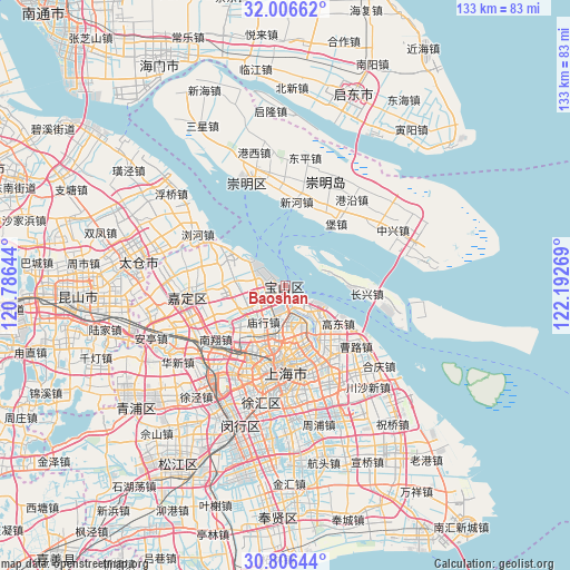
Baoshan GPS coordinates[2]
31° 24' 30.42" North, 121° 29' 22.416" East
| Map corner | latitude | longitude |
|---|---|---|
| Upper-left | 32.00662°, | 120.78644° |
| Center: | 31.40845°, | 121.48956° |
| Lower-right: | 30.80644°, | 122.19269° |
| Map W x H: | 133.4×133.4 km | = 82.9×82.9mi |
| max Lat: | 53.31946° ⇑42.2% North |
| Baoshan: | 31.40845° |
| min Lat: | ⇓57.8% South 18.22056° |
| min Long | Baoshan | max Long |
| 75.07348° | 121.48956° | 134.28917° |
| W 90%⇐ | ⇒10% E |
Elevation
Elevation of Baoshan is 5 m = 16 ft, and this is 479.8 m = 1574 ft below average elevation for this country.
| Max E: |
5622 m = 18445 ft | 97.2% |
| Avg. | 484.8 m = 1591 ft | |
| Baoshan | 5 m = 16 ft | |
Min E: |
-3 m = -10 ft | 2.8% |
See also: China elevation on elevation.city.
Geographical zone
Baoshan is located in North temperate zone (between Tropic of Cancer and the Arctic Circle). Distance of this Northern Tropic circle is 886.4 km =550.8 mi to South.| Distance of | km | miles | from Baoshan |
|---|---|---|---|
| North Pole | 6514.8 | 4048.1 | to North |
| Arctic Circle | 3908.9 | 2428.9 | to North |
| Tropic Cancer | 886.4 | 550.8 | to South |
| Equator | 3492.3 | 2170 | to South |


Nearby cities:
15 places around Baoshan: (largest is in red/bold)
• Changning
22.2 km =13.8 mi,  197°
197°
• Changzheng
22.1 km =13.7 mi,  211°
211°
• Hongkou
17.6 km =10.9 mi,  180°
180°
• Huamu
22.6 km =14 mi,  166°
166°
• Luojing
16.2 km =10.1 mi,  298°
298°
• Luwan
22.3 km =13.9 mi,  186°
186°
• Malu
18.9 km =11.7 mi,  259°
259°
• Nanxiang
20.8 km =12.9 mi,  234°
234°
• Pudong
19.6 km =12.2 mi, 169°
• Shanghai
20.9 km =13 mi, 188°
• Xinchenglu
21.6 km =13.4 mi, 264°
• Xuhang
20.8 km =12.9 mi,  271°
271°
• Yangpu
16.5 km =10.3 mi, 170°
• Zhabei
16.9 km =10.5 mi, 189°
• Zhenxin
22.2 km =13.8 mi,  215°
215°
Sources, notices
• [Note1] Compared only with cities in China existing in our database
• [Src1] Map data: © OpenStreetMap contributors (CC-BY-SA)
• [Src2] Other city data from geonames.org with taken over terms of usage.
• [Src3] Geographical zone / Annual Mean Temperature by Robert A. Rohde @ Wikipedia
