Tongshan geodata
Tongshan (Jiangsu) is a seat of a third-order administrative division; located in China in Asia/Shanghai (GMT+8) time zone. With population of 1,199,193 people, there are 56 cities with bigger population in this country. Compared to other cities in China, 71% of cities are located further ↓South; 66.8% of cities are located further ←West and 74.8% of cities have higher elevation than Tongshan. Note1


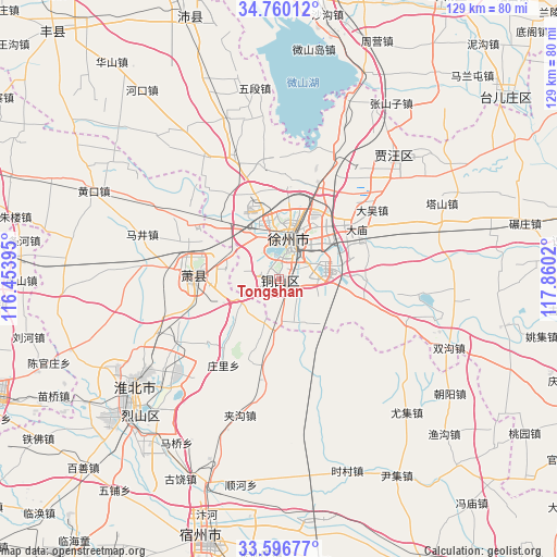
Tongshan GPS coordinates[2]
34° 10' 49.62" North, 117° 9' 25.452" East
| Map corner | latitude | longitude |
|---|---|---|
| Upper-left | 34.76012°, | 116.45395° |
| Center: | 34.18045°, | 117.15707° |
| Lower-right: | 33.59677°, | 117.8602° |
| Map W x H: | 129.4×129.4 km | = 80.4×80.4mi |
| max Lat: | 53.31946° ⇑29% North |
| Tongshan: | 34.18045° |
| min Lat: | ⇓71% South 18.22056° |
| min Long | Tongshan | max Long |
| 75.07348° | 117.15707° | 134.28917° |
| W 66.8%⇐ | ⇒33.2% E |
Elevation
Elevation of Tongshan is 37 m = 121 ft, and this is 447.8 m = 1469 ft below average elevation for this country.
| Max E: |
5622 m = 18445 ft | 74.8% |
| Avg. | 484.8 m = 1591 ft | |
| Tongshan | 37 m = 121 ft | |
Min E: |
-3 m = -10 ft | 25.2% |
See also: Tongshan elevation on elevation.city.
Geographical zone
Tongshan is located in North temperate zone (between Tropic of Cancer and the Arctic Circle). Distance of this Northern Tropic circle is 1194.6 km =742.3 mi to South.| Distance of | km | miles | from Tongshan |
|---|---|---|---|
| North Pole | 6206.6 | 3856.6 | to North |
| Arctic Circle | 3600.7 | 2237.4 | to North |
| Tropic Cancer | 1194.6 | 742.3 | to South |
| Equator | 3800.5 | 2361.5 | to South |


Nearby cities:
15 places around Tongshan: (largest is in red/bold)
• Bolinzi
55.2 km =34.3 mi,  147°
147°
• Dangcheng
76.8 km =47.7 mi,  290°
290°
• Duji
36.5 km =22.7 mi,  236°
236°
• Huaibei
40.7 km =25.3 mi, 235°
• Jiuli
12.7 km =7.9 mi,  351°
351°
• Longcheng
19 km =11.8 mi,  271°
271°
• Peicheng
65.4 km =40.6 mi,  340°
340°
• Pizhou
74.3 km =46.2 mi,  78°
78°
• Suixi
47.7 km =29.6 mi,  227°
227°
• Suzhou
62.7 km =39 mi,  195°
195°
• Tangzhai
59.1 km =36.7 mi,  298°
298°
• Taozhuang
76.2 km =47.3 mi,  12°
12°
• Xiazhen
69.3 km =43.1 mi,  356°
356°
• Xuzhou
12 km =7.5 mi, 77°
• Yanji
69.3 km =43.1 mi,  249°
249°
Sources, notices
• [Note1] Compared only with cities in China existing in our database
• [Src1] Map data: © OpenStreetMap contributors (CC-BY-SA)
• [Src2] Other city data from geonames.org with taken over terms of usage.
• [Src3] Geographical zone / Annual Mean Temperature by Robert A. Rohde @ Wikipedia
