Yanji geodata
Yanji (Henan) is a seat of a third-order administrative division; located in China in Asia/Shanghai (GMT+8) time zone. In our database, there are 1268 cities with bigger population. Compared to other cities in China, 69.9% of cities are located further ↓South; 62.8% of cities are located further ←West and 76.2% of cities have higher elevation than Yanji. Note1


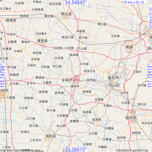
Yanji GPS coordinates[2]
33° 57' 55.08" North, 116° 27' 3.6" East
| Map corner | latitude | longitude |
|---|---|---|
| Upper-left | 34.54645°, | 115.74788° |
| Center: | 33.9653°, | 116.451° |
| Lower-right: | 33.38015°, | 117.15413° |
| Map W x H: | 129.7×129.7 km | = 80.6×80.6mi |
| max Lat: | 53.31946° ⇑30.1% North |
| Yanji: | 33.9653° |
| min Lat: | ⇓69.9% South 18.22056° |
| min Long | Yanji | max Long |
| 75.07348° | 116.451° | 134.28917° |
| W 62.8%⇐ | ⇒37.2% E |
Elevation
Elevation of Yanji is 34 m = 112 ft, and this is 450.8 m = 1479 ft below average elevation for this country.
| Max E: |
5622 m = 18445 ft | 76.2% |
| Avg. | 484.8 m = 1591 ft | |
| Yanji | 34 m = 112 ft | |
Min E: |
-3 m = -10 ft | 23.8% |
See also: China elevation on elevation.city.
Geographical zone
Yanji is located in North temperate zone (between Tropic of Cancer and the Arctic Circle). Distance of this Northern Tropic circle is 1170.7 km =727.4 mi to South.| Distance of | km | miles | from Yanji |
|---|---|---|---|
| North Pole | 6230.5 | 3871.5 | to North |
| Arctic Circle | 3624.6 | 2252.2 | to North |
| Tropic Cancer | 1170.7 | 727.4 | to South |
| Equator | 3776.6 | 2346.7 | to South |


Nearby cities:
15 places around Yanji: (largest is in red/bold)
• Bozhou
63.6 km =39.5 mi,  261°
261°
• Chezhan
62.5 km =38.8 mi,  321°
321°
• Dangcheng
51.9 km =32.2 mi,  352°
352°
• Duji
35 km =21.7 mi,  84°
84°
• Guoyang Chengguanzhen
55 km =34.2 mi,  201°
201°
• Huaibei
31.4 km =19.5 mi,  88°
88°
• Jiuli
72.9 km =45.3 mi,  59°
59°
• Longcheng
52.1 km =32.4 mi, 62°
• Mengcheng Chengguanzhen
78.5 km =48.8 mi,  172°
172°
• Suixi
31 km =19.3 mi,  105°
105°
• Suzhou
61 km =37.9 mi,  126°
126°
• Tangzhai
53.6 km =33.3 mi,  13°
13°
• Tongshan
69.3 km =43.1 mi,  69°
69°
• Xiayi Chengguanzhen
43.2 km =26.8 mi,  314°
314°
• Xuzhou
81.2 km =50.5 mi, 70°
Sources, notices
• [Note1] Compared only with cities in China existing in our database
• [Src1] Map data: © OpenStreetMap contributors (CC-BY-SA)
• [Src2] Other city data from geonames.org with taken over terms of usage.
• [Src3] Geographical zone / Annual Mean Temperature by Robert A. Rohde @ Wikipedia
