Xuzhou geodata
Xuzhou (Jiangsu) is a seat of a second-order administrative division; located in China in Asia/Shanghai (GMT+8) time zone. In our database, there are 1268 cities with bigger population. Compared to other cities in China, 71.1% of cities are located further ↓South; 67.7% of cities are located further ←West and 75.7% of cities have higher elevation than Xuzhou. Note1


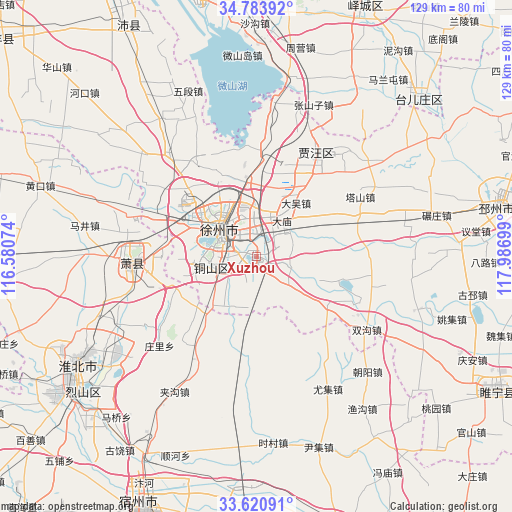
Xuzhou GPS coordinates[2]
34° 12' 15.912" North, 117° 17' 1.896" East
| Map corner | latitude | longitude |
|---|---|---|
| Upper-left | 34.78392°, | 116.58074° |
| Center: | 34.20442°, | 117.28386° |
| Lower-right: | 33.62091°, | 117.98699° |
| Map W x H: | 129.3×129.3 km | = 80.3×80.3mi |
| max Lat: | 53.31946° ⇑28.9% North |
| Xuzhou: | 34.20442° |
| min Lat: | ⇓71.1% South 18.22056° |
| min Long | Xuzhou | max Long |
| 75.07348° | 117.28386° | 134.28917° |
| W 67.7%⇐ | ⇒32.3% E |
Elevation
Elevation of Xuzhou is 35 m = 115 ft, and this is 449.8 m = 1476 ft below average elevation for this country.
| Max E: |
5622 m = 18445 ft | 75.7% |
| Avg. | 484.8 m = 1591 ft | |
| Xuzhou | 35 m = 115 ft | |
Min E: |
-3 m = -10 ft | 24.3% |
See also: China elevation on elevation.city.
Geographical zone
Xuzhou is located in North temperate zone (between Tropic of Cancer and the Arctic Circle). Distance of this Northern Tropic circle is 1197.3 km =744 mi to South.| Distance of | km | miles | from Xuzhou |
|---|---|---|---|
| North Pole | 6203.9 | 3854.9 | to North |
| Arctic Circle | 3598 | 2235.7 | to North |
| Tropic Cancer | 1197.3 | 744 | to South |
| Equator | 3803.2 | 2363.2 | to South |


Nearby cities:
15 places around Xuzhou: (largest is in red/bold)
• Bolinzi
52.3 km =32.5 mi,  159°
159°
• Duji
47.8 km =29.7 mi,  241°
241°
• Huaibei
52 km =32.3 mi, 240°
• Jiuli
16.7 km =10.4 mi,  306°
306°
• Longcheng
30.7 km =19.1 mi,  265°
265°
• Peicheng
67.7 km =42.1 mi,  330°
330°
• Pizhou
62.4 km =38.8 mi,  79°
79°
• Suicheng
68.9 km =42.8 mi,  119°
119°
• Suixi
58.5 km =36.4 mi,  233°
233°
• Suzhou
69.2 km =43 mi,  204°
204°
• Tangzhai
68.5 km =42.6 mi,  291°
291°
• Taozhuang
71.9 km =44.7 mi,  3°
3°
• Tongshan
12 km =7.5 mi,  257°
257°
• Xiazhen
68.3 km =42.4 mi,  346°
346°
• Zaozhuang
77.5 km =48.2 mi,  18°
18°
Sources, notices
• [Note1] Compared only with cities in China existing in our database
• [Src1] Map data: © OpenStreetMap contributors (CC-BY-SA)
• [Src2] Other city data from geonames.org with taken over terms of usage.
• [Src3] Geographical zone / Annual Mean Temperature by Robert A. Rohde @ Wikipedia
