Zhangzhu geodata
Zhangzhu (Jiangsu) is a seat of a fourth-order administrative division; located in China in Asia/Shanghai (GMT+8) time zone. In our database, there are 1268 cities with bigger population. Compared to other cities in China, 56.8% of cities are located further ↓South; 79.6% of cities are located further ←West and 87.7% of cities have higher elevation than Zhangzhu. Note1


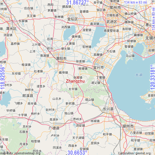
Zhangzhu GPS coordinates[2]
31° 16' 5.52" North, 119° 37' 43.248" East
| Map corner | latitude | longitude |
|---|---|---|
| Upper-left | 31.86727°, | 118.92556° |
| Center: | 31.2682°, | 119.62868° |
| Lower-right: | 30.6653°, | 120.33181° |
| Map W x H: | 133.6×133.6 km | = 83×83mi |
| max Lat: | 53.31946° ⇑43.2% North |
| Zhangzhu: | 31.2682° |
| min Lat: | ⇓56.8% South 18.22056° |
| min Long | Zhangzhu | max Long |
| 75.07348° | 119.62868° | 134.28917° |
| W 79.6%⇐ | ⇒20.4% E |
Elevation
Elevation of Zhangzhu is 12 m = 39 ft, and this is 472.8 m = 1551 ft below average elevation for this country.
| Max E: |
5622 m = 18445 ft | 87.7% |
| Avg. | 484.8 m = 1591 ft | |
| Zhangzhu | 12 m = 39 ft | |
Min E: |
-3 m = -10 ft | 12.3% |
See also: China elevation on elevation.city.
Geographical zone
Zhangzhu is located in North temperate zone (between Tropic of Cancer and the Arctic Circle). Distance of this Northern Tropic circle is 870.8 km =541.1 mi to South.| Distance of | km | miles | from Zhangzhu |
|---|---|---|---|
| North Pole | 6530.4 | 4057.8 | to North |
| Arctic Circle | 3924.5 | 2438.6 | to North |
| Tropic Cancer | 870.8 | 541.1 | to South |
| Equator | 3476.7 | 2160.3 | to South |


Nearby cities:
15 places around Zhangzhu: (largest is in red/bold)
• Baixian
17.6 km =10.9 mi,  162°
162°
• Daibu
13.4 km =8.3 mi,  290°
290°
• Dingshu
21 km =13 mi,  93°
93°
• Huaikan
22.5 km =14 mi,  167°
167°
• Licheng
22.5 km =14 mi,  322°
322°
• Meishan
20.9 km =13 mi,  151°
151°
• Taihua
10.5 km =6.5 mi,  204°
204°
• Tianmuhu
19.1 km =11.9 mi, 289°
• Xinhang
22.9 km =14.2 mi, 196°
• Xinjie
16 km =9.9 mi,  45°
45°
• Xizhu
6.3 km =3.9 mi, 291°
• Xushe
14.4 km =8.9 mi,  8°
8°
• Yangxiang
23.7 km =14.7 mi,  350°
350°
• Yicheng
20.9 km =13 mi,  60°
60°
• Zhoucheng
26.1 km =16.2 mi, 288°
Sources, notices
• [Note1] Compared only with cities in China existing in our database
• [Src1] Map data: © OpenStreetMap contributors (CC-BY-SA)
• [Src2] Other city data from geonames.org with taken over terms of usage.
• [Src3] Geographical zone / Annual Mean Temperature by Robert A. Rohde @ Wikipedia
