Xujiang geodata
Xujiang (Jiangxi) is a seat of a third-order administrative division; located in China in Asia/Shanghai (GMT+8) time zone. In our database, there are 1268 cities with bigger population. Compared to other cities in China, 79.2% of cities are located further ↑North; 61.9% of cities are located further ←West and 53.2% of cities have higher elevation than Xujiang. Note1


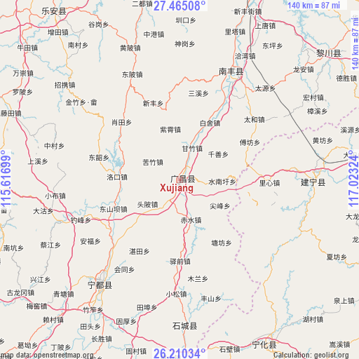
Xujiang GPS coordinates[2]
26° 50' 22.02" North, 116° 19' 12.396" East
| Map corner | latitude | longitude |
|---|---|---|
| Upper-left | 27.46508°, | 115.61699° |
| Center: | 26.83945°, | 116.32011° |
| Lower-right: | 26.21034°, | 117.02324° |
| Map W x H: | 139.5×139.5 km | = 86.7×86.7mi |
| max Lat: | 53.31946° ⇑79.2% North |
| Xujiang: | 26.83945° |
| min Lat: | ⇓20.8% South 18.22056° |
| min Long | Xujiang | max Long |
| 75.07348° | 116.32011° | 134.28917° |
| W 61.9%⇐ | ⇒38.1% E |
Elevation
Elevation of Xujiang is 142 m = 466 ft, and this is 342.8 m = 1125 ft below average elevation for this country.
| Max E: |
5622 m = 18445 ft | 53.2% |
| Avg. | 484.8 m = 1591 ft | |
| Xujiang | 142 m = 466 ft | |
Min E: |
-3 m = -10 ft | 46.8% |
See also: China elevation on elevation.city.
Geographical zone
Xujiang is located in North temperate zone (between Tropic of Cancer and the Arctic Circle). Distance of this Northern Tropic circle is 378.3 km =235.1 mi to South.| Distance of | km | miles | from Xujiang |
|---|---|---|---|
| North Pole | 7022.8 | 4363.8 | to North |
| Arctic Circle | 4416.9 | 2744.5 | to North |
| Tropic Cancer | 378.3 | 235.1 | to South |
| Equator | 2984.3 | 1854.4 | to South |


Nearby cities:
15 places around Xujiang: (largest is in red/bold)
• Baishe
25.2 km =15.7 mi,  27°
27°
• Changqiao
8.9 km =5.5 mi,  97°
97°
• Chishui
15.9 km =9.9 mi,  164°
164°
• Dongshanba
28 km =17.4 mi,  246°
246°
• Fufang
31 km =19.3 mi,  61°
61°
• Jianfeng
18.4 km =11.4 mi,  122°
122°
• Kefang
29.8 km =18.5 mi, 117°
• Kuzhu
12.8 km =8 mi,  303°
303°
• Luokou
24.8 km =15.4 mi,  273°
273°
• Qianshan
18 km =11.2 mi, 55°
• Shuinanxu
16.4 km =10.2 mi,  91°
91°
• Tangfang
29.1 km =18.1 mi,  146°
146°
• Toupi
15.7 km =9.8 mi,  233°
233°
• Yangxi
25.2 km =15.7 mi, 163°
• Zixiao
20.2 km =12.6 mi,  349°
349°
Sources, notices
• [Note1] Compared only with cities in China existing in our database
• [Src1] Map data: © OpenStreetMap contributors (CC-BY-SA)
• [Src2] Other city data from geonames.org with taken over terms of usage.
• [Src3] Geographical zone / Annual Mean Temperature by Robert A. Rohde @ Wikipedia
