Baishe geodata
Baishe (Jiangxi) is a seat of a fourth-order administrative division; located in China in Asia/Shanghai (GMT+8) time zone. In our database, there are 1268 cities with bigger population. Compared to other cities in China, 78.5% of cities are located further ↑North; 62.7% of cities are located further ←West and 57.1% of cities have higher elevation than Baishe. Note1


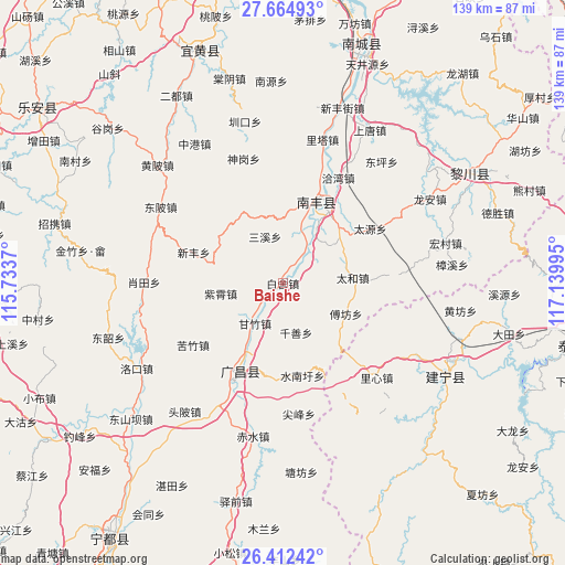
Baishe GPS coordinates[2]
27° 2' 25.512" North, 116° 26' 12.552" East
| Map corner | latitude | longitude |
|---|---|---|
| Upper-left | 27.66493°, | 115.7337° |
| Center: | 27.04042°, | 116.43682° |
| Lower-right: | 26.41242°, | 117.13995° |
| Map W x H: | 139.3×139.3 km | = 86.6×86.6mi |
| max Lat: | 53.31946° ⇑78.5% North |
| Baishe: | 27.04042° |
| min Lat: | ⇓21.5% South 18.22056° |
| min Long | Baishe | max Long |
| 75.07348° | 116.43682° | 134.28917° |
| W 62.7%⇐ | ⇒37.3% E |
Elevation
Elevation of Baishe is 117 m = 384 ft, and this is 367.8 m = 1207 ft below average elevation for this country.
| Max E: |
5622 m = 18445 ft | 57.1% |
| Avg. | 484.8 m = 1591 ft | |
| Baishe | 117 m = 384 ft | |
Min E: |
-3 m = -10 ft | 42.9% |
See also: China elevation on elevation.city.
Geographical zone
Baishe is located in North temperate zone (between Tropic of Cancer and the Arctic Circle). Distance of this Northern Tropic circle is 400.7 km =249 mi to South.| Distance of | km | miles | from Baishe |
|---|---|---|---|
| North Pole | 7000.4 | 4349.8 | to North |
| Arctic Circle | 4394.6 | 2730.7 | to North |
| Tropic Cancer | 400.7 | 249 | to South |
| Equator | 3006.6 | 1868.2 | to South |


Nearby cities:
15 places around Baishe: (largest is in red/bold)
• Changqiao
23.6 km =14.7 mi,  186°
186°
• Fufang
17.3 km =10.7 mi,  115°
115°
• Kuzhu
27 km =16.8 mi,  235°
235°
• Laixi
23.4 km =14.5 mi,  36°
36°
• Qianshan
12.6 km =7.8 mi,  164°
164°
• Qiawan
29.4 km =18.3 mi,  27°
27°
• Qincheng
21.3 km =13.2 mi, 25°
• Sangtian
16 km =9.9 mi,  53°
53°
• Sanxi
12.3 km =7.6 mi,  339°
339°
• Shishan
20 km =12.4 mi,  17°
17°
• Shuinanxu
23.3 km =14.5 mi,  168°
168°
• Taihe
17.3 km =10.7 mi,  85°
85°
• Xinfeng
23.4 km =14.5 mi,  288°
288°
• Xujiang
25.2 km =15.7 mi,  207°
207°
• Zixiao
15.5 km =9.6 mi,  260°
260°
Sources, notices
• [Note1] Compared only with cities in China existing in our database
• [Src1] Map data: © OpenStreetMap contributors (CC-BY-SA)
• [Src2] Other city data from geonames.org with taken over terms of usage.
• [Src3] Geographical zone / Annual Mean Temperature by Robert A. Rohde @ Wikipedia
