Xiuying geodata
Xiuying (Hainan) is a populated place; located in China in Asia/Shanghai (GMT+8) time zone. With population of 290,000 people, there are 181 cities with bigger population in this country. Compared to other cities in China, 98.7% of cities are located further ↑North; 70% of cities are located further →East and 84.9% of cities have higher elevation than Xiuying. Note1


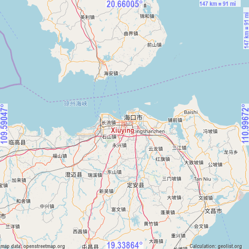
Xiuying GPS coordinates[2]
20° 0' 2.628" North, 110° 17' 36.924" East
| Map corner | latitude | longitude |
|---|---|---|
| Upper-left | 20.66005°, | 109.59047° |
| Center: | 20.00073°, | 110.29359° |
| Lower-right: | 19.33864°, | 110.99672° |
| Map W x H: | 146.9×146.9 km | = 91.3×91.3mi |
| max Lat: | 53.31946° ⇑98.7% North |
| Xiuying: | 20.00073° |
| min Lat: | ⇓1.3% South 18.22056° |
| min Long | Xiuying | max Long |
| 75.07348° | 110.29359° | 134.28917° |
| W 30%⇐ | ⇒70% E |
Elevation
Elevation of Xiuying is 16 m = 52 ft, and this is 468.8 m = 1538 ft below average elevation for this country.
| Max E: |
5622 m = 18445 ft | 84.9% |
| Avg. | 484.8 m = 1591 ft | |
| Xiuying | 16 m = 52 ft | |
Min E: |
-3 m = -10 ft | 15.1% |
See also: Xiuying elevation on elevation.city.
Geographical zone
Xiuying is located in North Torrid zone (between Equator and Tropic of Cancer). Distance of this Northern Tropic circle is 382 km =237.4 mi to North.| Distance of | km | miles | from Xiuying |
|---|---|---|---|
| North Pole | 7783.2 | 4836.3 | to North |
| Arctic Circle | 5177.3 | 3217 | to North |
| Tropic Cancer | 382 | 237.4 | to North |
| Equator | 2223.9 | 1381.9 | to South |


Nearby cities:
15 places around Xiuying: (largest is in red/bold)
• Changliu
9.8 km =6.1 mi,  278°
278°
• Dongying
13.8 km =8.6 mi,  65°
65°
• Haikou
7.1 km =4.4 mi,  45°
45°
• Haixiu
2.2 km =1.4 mi,  301°
301°
• Laocheng
18.7 km =11.6 mi,  257°
257°
• Lingshan
14.5 km =9 mi,  104°
104°
• Longqiao
11.6 km =7.2 mi,  146°
146°
• Longtang
17.8 km =11.1 mi,  136°
136°
• Mei’an
17.7 km =11 mi,  219°
219°
• Qiongshan
6.4 km =4 mi,  84°
84°
• Shishan
11.8 km =7.3 mi,  232°
232°
• Xinpo
26.6 km =16.5 mi,  163°
163°
• Yongxing
12.3 km =7.6 mi,  195°
195°
• Yunlong
22.8 km =14.2 mi,  127°
127°
• Zuntan
20.7 km =12.9 mi,  178°
178°
Sources, notices
• [Note1] Compared only with cities in China existing in our database
• [Src1] Map data: © OpenStreetMap contributors (CC-BY-SA)
• [Src2] Other city data from geonames.org with taken over terms of usage.
• [Src3] Geographical zone / Annual Mean Temperature by Robert A. Rohde @ Wikipedia
