Yongxing geodata
Yongxing (Hainan) is a seat of a fourth-order administrative division; located in China in Asia/Shanghai (GMT+8) time zone. In our database, there are 1268 cities with bigger population. Compared to other cities in China, 98.8% of cities are located further ↑North; 70.1% of cities are located further →East and 60.8% of cities have higher elevation than Yongxing. Note1


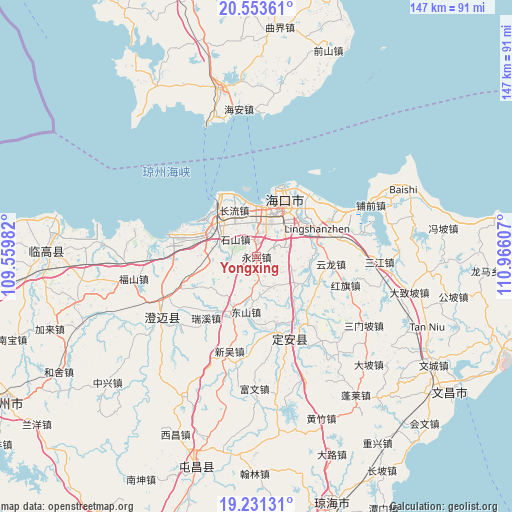
Yongxing GPS coordinates[2]
19° 53' 37.824" North, 110° 15' 46.584" East
| Map corner | latitude | longitude |
|---|---|---|
| Upper-left | 20.55361°, | 109.55982° |
| Center: | 19.89384°, | 110.26294° |
| Lower-right: | 19.23131°, | 110.96607° |
| Map W x H: | 147×147 km | = 91.3×91.3mi |
| max Lat: | 53.31946° ⇑98.8% North |
| Yongxing: | 19.89384° |
| min Lat: | ⇓1.2% South 18.22056° |
| min Long | Yongxing | max Long |
| 75.07348° | 110.26294° | 134.28917° |
| W 29.9%⇐ | ⇒70.1% E |
Elevation
Elevation of Yongxing is 94 m = 308 ft, and this is 390.8 m = 1282 ft below average elevation for this country.
| Max E: |
5622 m = 18445 ft | 60.8% |
| Avg. | 484.8 m = 1591 ft | |
| Yongxing | 94 m = 308 ft | |
Min E: |
-3 m = -10 ft | 39.2% |
See also: China elevation on elevation.city.
Geographical zone
Yongxing is located in North Torrid zone (between Equator and Tropic of Cancer). Distance of this Northern Tropic circle is 393.9 km =244.8 mi to North.| Distance of | km | miles | from Yongxing |
|---|---|---|---|
| North Pole | 7795.1 | 4843.6 | to North |
| Arctic Circle | 5189.2 | 3224.4 | to North |
| Tropic Cancer | 393.9 | 244.8 | to North |
| Equator | 2212 | 1374.5 | to South |


Nearby cities:
15 places around Yongxing: (largest is in red/bold)
• Changliu
14.8 km =9.2 mi,  333°
333°
• Dongshan
16.1 km =10 mi,  191°
191°
• Haikou
18.8 km =11.7 mi,  25°
25°
• Haixiu
13.1 km =8.1 mi,  6°
6°
• Laocheng
16.9 km =10.5 mi,  297°
297°
• Lingshan
19.2 km =11.9 mi,  64°
64°
• Longqiao
10 km =6.2 mi,  77°
77°
• Longtang
15.5 km =9.6 mi,  93°
93°
• Mei’an
8.2 km =5.1 mi,  257°
257°
• Qiongshan
15.7 km =9.8 mi,  37°
37°
• Shishan
7.7 km =4.8 mi,  307°
307°
• Xinpo
17.3 km =10.7 mi,  141°
141°
• Xiuying
12.3 km =7.6 mi,  15°
15°
• Yongfa
17.7 km =11 mi,  203°
203°
• Zuntan
9.6 km =6 mi,  156°
156°
Sources, notices
• [Note1] Compared only with cities in China existing in our database
• [Src1] Map data: © OpenStreetMap contributors (CC-BY-SA)
• [Src2] Other city data from geonames.org with taken over terms of usage.
• [Src3] Geographical zone / Annual Mean Temperature by Robert A. Rohde @ Wikipedia
