Laocheng geodata
Laocheng (Hainan) is a seat of a fourth-order administrative division; located in China in Asia/Shanghai (GMT+8) time zone. In our database, there are 1268 cities with bigger population. Compared to other cities in China, 98.8% of cities are located further ↑North; 70.7% of cities are located further →East and 85.5% of cities have higher elevation than Laocheng. Note1


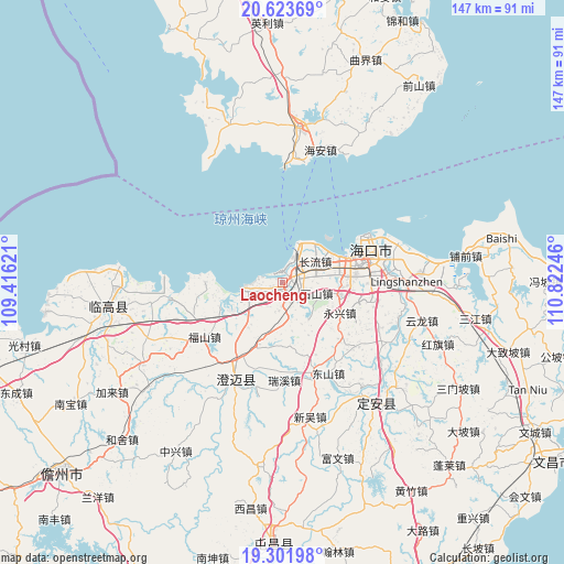
Laocheng GPS coordinates[2]
19° 57' 51.192" North, 110° 7' 9.588" East
| Map corner | latitude | longitude |
|---|---|---|
| Upper-left | 20.62369°, | 109.41621° |
| Center: | 19.96422°, | 110.11933° |
| Lower-right: | 19.30198°, | 110.82246° |
| Map W x H: | 147×147 km | = 91.3×91.3mi |
| max Lat: | 53.31946° ⇑98.8% North |
| Laocheng: | 19.96422° |
| min Lat: | ⇓1.2% South 18.22056° |
| min Long | Laocheng | max Long |
| 75.07348° | 110.11933° | 134.28917° |
| W 29.3%⇐ | ⇒70.7% E |
Elevation
Elevation of Laocheng is 15 m = 49 ft, and this is 469.8 m = 1541 ft below average elevation for this country.
| Max E: |
5622 m = 18445 ft | 85.5% |
| Avg. | 484.8 m = 1591 ft | |
| Laocheng | 15 m = 49 ft | |
Min E: |
-3 m = -10 ft | 14.5% |
See also: China elevation on elevation.city.
Geographical zone
Laocheng is located in North Torrid zone (between Equator and Tropic of Cancer). Distance of this Northern Tropic circle is 386.1 km =239.9 mi to North.| Distance of | km | miles | from Laocheng |
|---|---|---|---|
| North Pole | 7787.2 | 4838.7 | to North |
| Arctic Circle | 5181.4 | 3219.6 | to North |
| Tropic Cancer | 386.1 | 239.9 | to North |
| Equator | 2219.8 | 1379.3 | to South |


Nearby cities:
15 places around Laocheng: (largest is in red/bold)
• Changliu
10.1 km =6.3 mi,  57°
57°
• Dongshan
26.4 km =16.4 mi,  153°
153°
• Fushan
24.7 km =15.3 mi,  234°
234°
• Haikou
24.9 km =15.5 mi,  68°
68°
• Haixiu
17.2 km =10.7 mi, 72°
• Longqiao
25.3 km =15.7 mi,  102°
102°
• Mei’an
11.8 km =7.3 mi,  143°
143°
• Qiaotou
20.2 km =12.6 mi,  270°
270°
• Qiongshan
25 km =15.5 mi,  79°
79°
• Ruixi
25.6 km =15.9 mi,  178°
178°
• Shishan
9.4 km =5.8 mi,  109°
109°
• Xiuying
18.7 km =11.6 mi, 77°
• Yongfa
25.3 km =15.7 mi,  161°
161°
• Yongxing
16.9 km =10.5 mi,  117°
117°
• Zuntan
25.1 km =15.6 mi,  131°
131°
Sources, notices
• [Note1] Compared only with cities in China existing in our database
• [Src1] Map data: © OpenStreetMap contributors (CC-BY-SA)
• [Src2] Other city data from geonames.org with taken over terms of usage.
• [Src3] Geographical zone / Annual Mean Temperature by Robert A. Rohde @ Wikipedia
