Changliu geodata
Changliu (Hainan) is a seat of a fourth-order administrative division; located in China in Asia/Shanghai (GMT+8) time zone. In our database, there are 1268 cities with bigger population. Compared to other cities in China, 98.7% of cities are located further ↑North; 70.4% of cities are located further →East and 77.7% of cities have higher elevation than Changliu. Note1


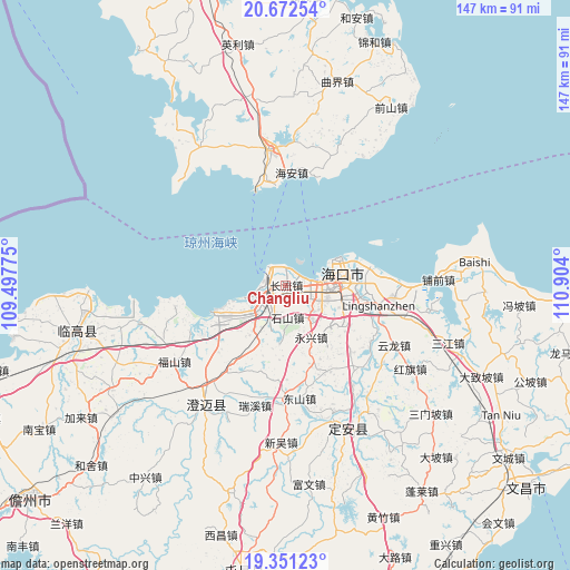
Changliu GPS coordinates[2]
20° 0' 47.772" North, 110° 12' 3.132" East
| Map corner | latitude | longitude |
|---|---|---|
| Upper-left | 20.67254°, | 109.49775° |
| Center: | 20.01327°, | 110.20087° |
| Lower-right: | 19.35123°, | 110.904° |
| Map W x H: | 146.9×146.9 km | = 91.3×91.3mi |
| max Lat: | 53.31946° ⇑98.7% North |
| Changliu: | 20.01327° |
| min Lat: | ⇓1.3% South 18.22056° |
| min Long | Changliu | max Long |
| 75.07348° | 110.20087° | 134.28917° |
| W 29.6%⇐ | ⇒70.4% E |
Elevation
Elevation of Changliu is 31 m = 102 ft, and this is 453.8 m = 1489 ft below average elevation for this country.
| Max E: |
5622 m = 18445 ft | 77.7% |
| Avg. | 484.8 m = 1591 ft | |
| Changliu | 31 m = 102 ft | |
Min E: |
-3 m = -10 ft | 22.3% |
See also: China elevation on elevation.city.
Geographical zone
Changliu is located in North Torrid zone (between Equator and Tropic of Cancer). Distance of this Northern Tropic circle is 380.7 km =236.6 mi to North.| Distance of | km | miles | from Changliu |
|---|---|---|---|
| North Pole | 7781.8 | 4835.4 | to North |
| Arctic Circle | 5175.9 | 3216.2 | to North |
| Tropic Cancer | 380.7 | 236.6 | to North |
| Equator | 2225.3 | 1382.7 | to South |


Nearby cities:
15 places around Changliu: (largest is in red/bold)
• Dongshan
29.3 km =18.2 mi,  173°
173°
• Dongying
22.6 km =14 mi,  78°
78°
• Haikou
15.1 km =9.4 mi, 76°
• Haixiu
7.9 km =4.9 mi,  91°
91°
• Laocheng
10.1 km =6.3 mi,  237°
237°
• Lingshan
24.2 km =15 mi,  101°
101°
• Longqiao
19.6 km =12.2 mi,  124°
124°
• Longtang
26.2 km =16.3 mi, 123°
• Mei’an
15.1 km =9.4 mi,  185°
185°
• Qiaotou
29.2 km =18.1 mi,  259°
259°
• Qiongshan
16 km =9.9 mi, 92°
• Shishan
8.7 km =5.4 mi,  177°
177°
• Xiuying
9.8 km =6.1 mi, 98°
• Yongxing
14.8 km =9.2 mi,  153°
153°
• Zuntan
24.4 km =15.2 mi,  155°
155°
Sources, notices
• [Note1] Compared only with cities in China existing in our database
• [Src1] Map data: © OpenStreetMap contributors (CC-BY-SA)
• [Src2] Other city data from geonames.org with taken over terms of usage.
• [Src3] Geographical zone / Annual Mean Temperature by Robert A. Rohde @ Wikipedia
