Mei’an geodata
Mei’an (Hainan) is a seat of a fourth-order administrative division; located in China in Asia/Shanghai (GMT+8) time zone. In our database, there are 1268 cities with bigger population. Compared to other cities in China, 98.9% of cities are located further ↑North; 70.4% of cities are located further →East and 61.5% of cities have higher elevation than Mei’an. Note1


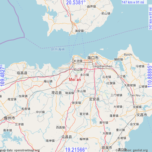
Mei’an GPS coordinates[2]
19° 52' 41.736" North, 110° 11' 8.952" East
| Map corner | latitude | longitude |
|---|---|---|
| Upper-left | 20.5381°, | 109.4827° |
| Center: | 19.87826°, | 110.18582° |
| Lower-right: | 19.21566°, | 110.88895° |
| Map W x H: | 147×147 km | = 91.3×91.3mi |
| max Lat: | 53.31946° ⇑98.9% North |
| Mei’an: | 19.87826° |
| min Lat: | ⇓1.1% South 18.22056° |
| min Long | Mei’an | max Long |
| 75.07348° | 110.18582° | 134.28917° |
| W 29.6%⇐ | ⇒70.4% E |
Elevation
Elevation of Mei’an is 90 m = 295 ft, and this is 394.8 m = 1295 ft below average elevation for this country.
| Max E: |
5622 m = 18445 ft | 61.5% |
| Avg. | 484.8 m = 1591 ft | |
| Mei’an | 90 m = 295 ft | |
Min E: |
-3 m = -10 ft | 38.5% |
See also: China elevation on elevation.city.
Geographical zone
Mei’an is located in North Torrid zone (between Equator and Tropic of Cancer). Distance of this Northern Tropic circle is 395.7 km =245.9 mi to North.| Distance of | km | miles | from Mei’an |
|---|---|---|---|
| North Pole | 7796.8 | 4844.7 | to North |
| Arctic Circle | 5190.9 | 3225.5 | to North |
| Tropic Cancer | 395.7 | 245.9 | to North |
| Equator | 2210.3 | 1373.4 | to South |


Nearby cities:
15 places around Mei’an: (largest is in red/bold)
• Changliu
15.1 km =9.4 mi,  5°
5°
• Dongshan
14.9 km =9.3 mi,  160°
160°
• Haikou
24.7 km =15.3 mi,  41°
41°
• Haixiu
17.5 km =10.9 mi,  32°
32°
• Laocheng
11.8 km =7.3 mi,  323°
323°
• Longqiao
18.2 km =11.3 mi,  77°
77°
• Longtang
23.6 km =14.7 mi,  88°
88°
• Qiongshan
22.6 km =14 mi,  51°
51°
• Ruixi
17.2 km =10.7 mi,  201°
201°
• Shishan
6.6 km =4.1 mi,  16°
16°
• Xinpo
22.2 km =13.8 mi,  122°
122°
• Xiuying
17.7 km =11 mi, 39°
• Yongfa
14.5 km =9 mi,  176°
176°
• Yongxing
8.2 km =5.1 mi, 77°
• Zuntan
13.8 km =8.6 mi, 120°
Sources, notices
• [Note1] Compared only with cities in China existing in our database
• [Src1] Map data: © OpenStreetMap contributors (CC-BY-SA)
• [Src2] Other city data from geonames.org with taken over terms of usage.
• [Src3] Geographical zone / Annual Mean Temperature by Robert A. Rohde @ Wikipedia
