Cuijiaba geodata
Cuijiaba (Hubei) is a seat of a fourth-order administrative division; located in China in Asia/Shanghai (GMT+8) time zone. In our database, there are 1268 cities with bigger population. Compared to other cities in China, 50.4% of cities are located further ↓South; 72% of cities are located further →East and 83.9% of cities have lower elevation than Cuijiaba. Note1


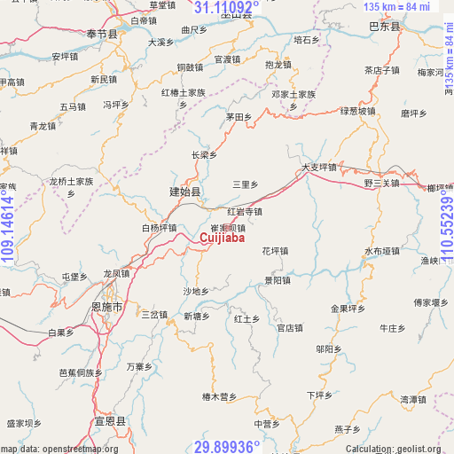
Cuijiaba GPS coordinates[2]
30° 30' 25.308" North, 109° 50' 57.336" East
| Map corner | latitude | longitude |
|---|---|---|
| Upper-left | 31.11092°, | 109.14614° |
| Center: | 30.50703°, | 109.84926° |
| Lower-right: | 29.89936°, | 110.55239° |
| Map W x H: | 134.7×134.7 km | = 83.7×83.7mi |
| max Lat: | 53.31946° ⇑49.6% North |
| Cuijiaba: | 30.50703° |
| min Lat: | ⇓50.4% South 18.22056° |
| min Long | Cuijiaba | max Long |
| 75.07348° | 109.84926° | 134.28917° |
| W 28%⇐ | ⇒72% E |
Elevation
Elevation of Cuijiaba is 911 m = 2989 ft, and this is 426.2 m = 1398 ft above average elevation for this country.
| Max E: |
5622 m = 18445 ft | 16.1% |
| Cuijiaba | 911 m 2989 ft | |
| Avg. | 484.8 m = 1591 ft | |
Min E: |
-3 m = -10 ft | 83.9% |
See also: China elevation on elevation.city.
Geographical zone
Cuijiaba is located in North temperate zone (between Tropic of Cancer and the Arctic Circle). Distance of this Northern Tropic circle is 786.1 km =488.5 mi to South.| Distance of | km | miles | from Cuijiaba |
|---|---|---|---|
| North Pole | 6615 | 4110.4 | to North |
| Arctic Circle | 4009.1 | 2491.1 | to North |
| Tropic Cancer | 786.1 | 488.5 | to South |
| Equator | 3392.1 | 2107.8 | to South |


Nearby cities:
15 places around Cuijiaba: (largest is in red/bold)
• Baiyangping
20.3 km =12.6 mi,  266°
266°
• Changliang
22.8 km =14.2 mi,  342°
342°
• Dazhiping
32.5 km =20.2 mi,  56°
56°
• Gaoping
28.1 km =17.5 mi,  51°
51°
• Heshuiping
8 km =5 mi,  2°
2°
• Hongtu
27.6 km =17.1 mi,  168°
168°
• Hongyansi
7 km =4.3 mi, 46°
• Huaping
15.1 km =9.4 mi,  118°
118°
• Jingyang
21.3 km =13.2 mi,  136°
136°
• Maotian
33.1 km =20.6 mi,  5°
5°
• Sanli
14 km =8.7 mi,  22°
22°
• Shadi
21.1 km =13.1 mi,  206°
206°
• Shangcunba
27.5 km =17.1 mi,  155°
155°
• Xintang
27.6 km =17.1 mi,  199°
199°
• Yezhou
16.2 km =10.1 mi,  311°
311°
Sources, notices
• [Note1] Compared only with cities in China existing in our database
• [Src1] Map data: © OpenStreetMap contributors (CC-BY-SA)
• [Src2] Other city data from geonames.org with taken over terms of usage.
• [Src3] Geographical zone / Annual Mean Temperature by Robert A. Rohde @ Wikipedia
