Nanhua geodata
Nanhua (Gansu) is a seat of a fourth-order administrative division; located in China in Asia/Shanghai (GMT+8) time zone. In our database, there are 1268 cities with bigger population. Compared to other cities in China, 84.2% of cities are located further ↓South; 94.7% of cities are located further →East and 90% of cities have lower elevation than Nanhua. Note1


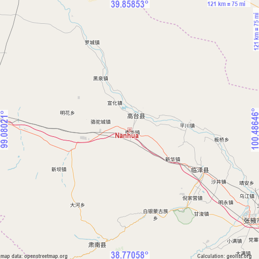
Nanhua GPS coordinates[2]
39° 19' 0.012" North, 99° 46' 59.988" East
| Map corner | latitude | longitude |
|---|---|---|
| Upper-left | 39.85853°, | 99.08021° |
| Center: | 39.31667°, | 99.78333° |
| Lower-right: | 38.77058°, | 100.48646° |
| Map W x H: | 121×121 km | = 75.2×75.2mi |
| max Lat: | 53.31946° ⇑15.8% North |
| Nanhua: | 39.31667° |
| min Lat: | ⇓84.2% South 18.22056° |
| min Long | Nanhua | max Long |
| 75.07348° | 99.78333° | 134.28917° |
| W 5.3%⇐ | ⇒94.7% E |
Elevation
Elevation of Nanhua is 1366 m = 4482 ft, and this is 881.2 m = 2891 ft above average elevation for this country.
| Max E: |
5622 m = 18445 ft | 10% |
| Nanhua | 1366 m 4482 ft | |
| Avg. | 484.8 m = 1591 ft | |
Min E: |
-3 m = -10 ft | 90% |
See also: China elevation on elevation.city.
Geographical zone
Nanhua is located in North temperate zone (between Tropic of Cancer and the Arctic Circle). Distance of this Northern Tropic circle is 1765.7 km =1097.2 mi to South.| Distance of | km | miles | from Nanhua |
|---|---|---|---|
| North Pole | 5635.5 | 3501.7 | to North |
| Arctic Circle | 3029.6 | 1882.5 | to North |
| Tropic Cancer | 1765.7 | 1097.2 | to South |
| Equator | 4371.6 | 2716.4 | to South |


Nearby cities:
15 places around Nanhua: (largest is in red/bold)
• Baiyin
45.2 km =28.1 mi,  168°
168°
• Banqiao
45.8 km =28.5 mi,  93°
93°
• Ganjun
51.3 km =31.9 mi,  139°
139°
• Gaotai Chengguanzhen
3.4 km =2.1 mi,  25°
25°
• Heiquan
26.4 km =16.4 mi,  327°
327°
• Hongwansi
55.9 km =34.7 mi,  196°
196°
• Hongyazi
45.2 km =28.1 mi,  246°
246°
• Liaoquan
21.8 km =13.5 mi,  80°
80°
• Luocheng
45.2 km =28.1 mi, 334°
• Minghai
37.5 km =23.3 mi,  302°
302°
• Qinglong
48.9 km =30.4 mi,  188°
188°
• Shahe
39.2 km =24.4 mi,  119°
119°
• Shajing
48.1 km =29.9 mi, 120°
• Xinba
36.9 km =22.9 mi,  241°
241°
• Xinhua
22.7 km =14.1 mi, 124°
Sources, notices
• [Note1] Compared only with cities in China existing in our database
• [Src1] Map data: © OpenStreetMap contributors (CC-BY-SA)
• [Src2] Other city data from geonames.org with taken over terms of usage.
• [Src3] Geographical zone / Annual Mean Temperature by Robert A. Rohde @ Wikipedia
