Xinglong geodata
Xinglong (Chongqing) is a seat of a fourth-order administrative division; located in China in Asia/Shanghai (GMT+8) time zone. In our database, there are 1268 cities with bigger population. Compared to other cities in China, 51.7% of cities are located further ↓South; 74.2% of cities are located further →East and 89% of cities have lower elevation than Xinglong. Note1


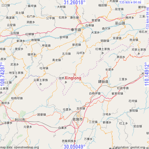
Xinglong GPS coordinates[2]
30° 39' 26.028" North, 109° 26' 45.564" East
| Map corner | latitude | longitude |
|---|---|---|
| Upper-left | 31.26018°, | 108.74287° |
| Center: | 30.65723°, | 109.44599° |
| Lower-right: | 30.05049°, | 110.14912° |
| Map W x H: | 134.5×134.5 km | = 83.6×83.6mi |
| max Lat: | 53.31946° ⇑48.3% North |
| Xinglong: | 30.65723° |
| min Lat: | ⇓51.7% South 18.22056° |
| min Long | Xinglong | max Long |
| 75.07348° | 109.44599° | 134.28917° |
| W 25.8%⇐ | ⇒74.2% E |
Elevation
Elevation of Xinglong is 1272 m = 4173 ft, and this is 787.2 m = 2583 ft above average elevation for this country.
| Max E: |
5622 m = 18445 ft | 11% |
| Xinglong | 1272 m 4173 ft | |
| Avg. | 484.8 m = 1591 ft | |
Min E: |
-3 m = -10 ft | 89% |
See also: China elevation on elevation.city.
Geographical zone
Xinglong is located in North temperate zone (between Tropic of Cancer and the Arctic Circle). Distance of this Northern Tropic circle is 802.8 km =498.8 mi to South.| Distance of | km | miles | from Xinglong |
|---|---|---|---|
| North Pole | 6598.3 | 4100 | to North |
| Arctic Circle | 3992.4 | 2480.8 | to North |
| Tropic Cancer | 802.8 | 498.8 | to South |
| Equator | 3408.8 | 2118.1 | to South |


Nearby cities:
15 places around Xinglong: (largest is in red/bold)
• Baiyangping
25.7 km =16 mi,  134°
134°
• Banqiao
18.1 km =11.2 mi,  245°
245°
• Chang’an
22.1 km =13.7 mi,  29°
29°
• Fengping
20.5 km =12.7 mi,  15°
15°
• Longfengba
30.5 km =19 mi,  168°
168°
• Longqiao
9.1 km =5.7 mi,  239°
239°
• Miaoyu
30.3 km =18.8 mi,  39°
39°
• Qinglong
22.7 km =14.1 mi,  306°
306°
• Taihe
17.7 km =11 mi,  264°
264°
• Taiyanghe
9.2 km =5.7 mi,  135°
135°
• Tuxiang
28.5 km =17.7 mi,  282°
282°
• Wuma
22.9 km =14.2 mi,  343°
343°
• Xinmin
27.4 km =17 mi,  4°
4°
• Yezhou
27.2 km =16.9 mi,  102°
102°
• Yunwu
31.3 km =19.4 mi, 258°
Sources, notices
• [Note1] Compared only with cities in China existing in our database
• [Src1] Map data: © OpenStreetMap contributors (CC-BY-SA)
• [Src2] Other city data from geonames.org with taken over terms of usage.
• [Src3] Geographical zone / Annual Mean Temperature by Robert A. Rohde @ Wikipedia
