Xiangxiang geodata
Xiangxiang (Hunan) is a populated place; located in China in Asia/Shanghai (GMT+8) time zone. With population of 87,592 people, there are 486 cities with bigger population in this country. Compared to other cities in China, 75.5% of cities are located further ↑North; 59.9% of cities are located further →East and 71.6% of cities have higher elevation than Xiangxiang. Note1


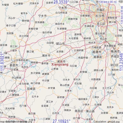
Xiangxiang GPS coordinates[2]
27° 43' 59.988" North, 112° 31' 59.988" East
| Map corner | latitude | longitude |
|---|---|---|
| Upper-left | 28.3539°, | 111.83021° |
| Center: | 27.73333°, | 112.53333° |
| Lower-right: | 27.10921°, | 113.23646° |
| Map W x H: | 138.4×138.4 km | = 86×86mi |
| max Lat: | 53.31946° ⇑75.5% North |
| Xiangxiang: | 27.73333° |
| min Lat: | ⇓24.5% South 18.22056° |
| min Long | Xiangxiang | max Long |
| 75.07348° | 112.53333° | 134.28917° |
| W 40.1%⇐ | ⇒59.9% E |
Elevation
Elevation of Xiangxiang is 46 m = 151 ft, and this is 438.8 m = 1440 ft below average elevation for this country.
| Max E: |
5622 m = 18445 ft | 71.6% |
| Avg. | 484.8 m = 1591 ft | |
| Xiangxiang | 46 m = 151 ft | |
Min E: |
-3 m = -10 ft | 28.4% |
See also: Xiangxiang elevation on elevation.city.
Geographical zone
Xiangxiang is located in North temperate zone (between Tropic of Cancer and the Arctic Circle). Distance of this Northern Tropic circle is 477.7 km =296.8 mi to South.| Distance of | km | miles | from Xiangxiang |
|---|---|---|---|
| North Pole | 6923.4 | 4302 | to North |
| Arctic Circle | 4317.5 | 2682.8 | to North |
| Tropic Cancer | 477.7 | 296.8 | to South |
| Equator | 3083.7 | 1916.1 | to South |


Nearby cities:
15 places around Xiangxiang: (largest is in red/bold)
• Bairuopu
58.1 km =36.1 mi,  26°
26°
• Datuo
54.6 km =33.9 mi,  48°
48°
• Huaminglou
36.4 km =22.6 mi,  12°
12°
• Huitang
34.8 km =21.6 mi,  325°
325°
• Laoliangcang
50.7 km =31.5 mi,  318°
318°
• Lianhua
48.4 km =30.1 mi, 28°
• Loudi
53 km =32.9 mi,  270°
270°
• Lukou
61 km =37.9 mi,  93°
93°
• Muyun
54.9 km =34.1 mi, 52°
• Pingtang
54.2 km =33.7 mi,  43°
43°
• Xiangtan
38.3 km =23.8 mi,  70°
70°
• Yisuhe
38.9 km =24.2 mi,  84°
84°
• Yongfeng
48.4 km =30.1 mi,  225°
225°
• Yujia’ao
57.7 km =35.9 mi, 332°
• Yutan
58.4 km =36.3 mi,  2°
2°
Sources, notices
• [Note1] Compared only with cities in China existing in our database
• [Src1] Map data: © OpenStreetMap contributors (CC-BY-SA)
• [Src2] Other city data from geonames.org with taken over terms of usage.
• [Src3] Geographical zone / Annual Mean Temperature by Robert A. Rohde @ Wikipedia
