Linfen geodata
Linfen (Shanxi) is a populated place; located in China in Asia/Shanghai (GMT+8) time zone. With population of 232,566 people, there are 210 cities with bigger population in this country. Compared to other cities in China, 77.4% of cities are located further ↓South; 64.9% of cities are located further →East and 71.9% of cities have lower elevation than Linfen. Note1


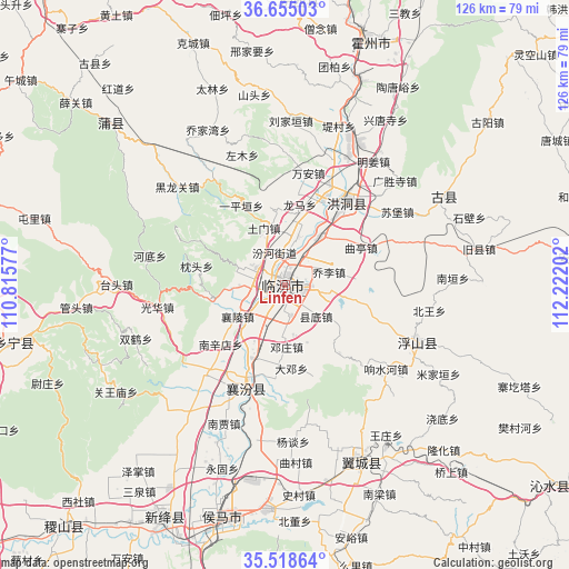
Linfen GPS coordinates[2]
36° 5' 20.004" North, 111° 31' 8.004" East
| Map corner | latitude | longitude |
|---|---|---|
| Upper-left | 36.65503°, | 110.81577° |
| Center: | 36.08889°, | 111.51889° |
| Lower-right: | 35.51864°, | 112.22202° |
| Map W x H: | 126.4×126.4 km | = 78.5×78.5mi |
| max Lat: | 53.31946° ⇑22.6% North |
| Linfen: | 36.08889° |
| min Lat: | ⇓77.4% South 18.22056° |
| min Long | Linfen | max Long |
| 75.07348° | 111.51889° | 134.28917° |
| W 35.1%⇐ | ⇒64.9% E |
Elevation
Elevation of Linfen is 451 m = 1480 ft, and this is 33.8 m = 111 ft below average elevation for this country.
| Max E: |
5622 m = 18445 ft | 28.1% |
| Avg. | 484.8 m = 1591 ft | |
| Linfen | 451 m = 1480 ft | |
Min E: |
-3 m = -10 ft | 71.9% |
See also: Linfen elevation on elevation.city.
Geographical zone
Linfen is located in North temperate zone (between Tropic of Cancer and the Arctic Circle). Distance of this Northern Tropic circle is 1406.8 km =874.1 mi to South.| Distance of | km | miles | from Linfen |
|---|---|---|---|
| North Pole | 5994.4 | 3724.7 | to North |
| Arctic Circle | 3388.5 | 2105.5 | to North |
| Tropic Cancer | 1406.8 | 874.1 | to South |
| Equator | 4012.7 | 2493.4 | to South |


Nearby cities:
15 places around Linfen: (largest is in red/bold)
• Dadeng
18.7 km =11.6 mi,  175°
175°
• Dahuaishu
24.1 km =15 mi,  35°
35°
• Dengzhuang
13.8 km =8.6 mi, 178°
• Fencheng
37.3 km =23.2 mi,  216°
216°
• Gucheng
26.7 km =16.6 mi, 222°
• Jingmao
27.3 km =17 mi,  212°
212°
• Licun
36.9 km =22.9 mi,  188°
188°
• Nanjia
33.8 km =21 mi,  203°
203°
• Nanxindian
19.6 km =12.2 mi,  227°
227°
• Taosi
21.4 km =13.3 mi, 184°
• Tiantan
32.1 km =19.9 mi,  115°
115°
• Xiangling
12.7 km =7.9 mi,  237°
237°
• Xijia
35.7 km =22.2 mi, 209°
• Xincheng
24.9 km =15.5 mi, 197°
• Yangtan
34.9 km =21.7 mi, 177°
Sources, notices
• [Note1] Compared only with cities in China existing in our database
• [Src1] Map data: © OpenStreetMap contributors (CC-BY-SA)
• [Src2] Other city data from geonames.org with taken over terms of usage.
• [Src3] Geographical zone / Annual Mean Temperature by Robert A. Rohde @ Wikipedia
