Xiamao geodata
Xiamao (Fujian) is a seat of a fourth-order administrative division; located in China in Asia/Shanghai (GMT+8) time zone. In our database, there are 1268 cities with bigger population. Compared to other cities in China, 80.2% of cities are located further ↑North; 69.4% of cities are located further ←West and 53.7% of cities have lower elevation than Xiamao. Note1


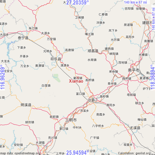
Xiamao GPS coordinates[2]
26° 34' 35.364" North, 117° 39' 56.916" East
| Map corner | latitude | longitude |
|---|---|---|
| Upper-left | 27.20359°, | 116.96269° |
| Center: | 26.57649°, | 117.66581° |
| Lower-right: | 25.94594°, | 118.36894° |
| Map W x H: | 139.8×139.8 km | = 86.9×86.9mi |
| max Lat: | 53.31946° ⇑80.2% North |
| Xiamao: | 26.57649° |
| min Lat: | ⇓19.8% South 18.22056° |
| min Long | Xiamao | max Long |
| 75.07348° | 117.66581° | 134.28917° |
| W 69.4%⇐ | ⇒30.6% E |
Elevation
Elevation of Xiamao is 195 m = 640 ft, and this is 289.8 m = 951 ft below average elevation for this country.
| Max E: |
5622 m = 18445 ft | 46.3% |
| Avg. | 484.8 m = 1591 ft | |
| Xiamao | 195 m = 640 ft | |
Min E: |
-3 m = -10 ft | 53.7% |
See also: China elevation on elevation.city.
Geographical zone
Xiamao is located in North temperate zone (between Tropic of Cancer and the Arctic Circle). Distance of this Northern Tropic circle is 349.1 km =216.9 mi to South.| Distance of | km | miles | from Xiamao |
|---|---|---|---|
| North Pole | 7052 | 4381.9 | to North |
| Arctic Circle | 4446.1 | 2762.7 | to North |
| Tropic Cancer | 349.1 | 216.9 | to South |
| Equator | 2955 | 1836.2 | to South |


Nearby cities:
15 places around Xiamao: (largest is in red/bold)
• Chenda
29.2 km =18.1 mi,  184°
184°
• Fukou
14.4 km =8.9 mi,  170°
170°
• Gaoqiao
11 km =6.8 mi,  99°
99°
• Gaosha
29 km =18 mi,  124°
124°
• Gaotang
26.4 km =16.4 mi,  342°
342°
• Guyong
26.1 km =16.2 mi,  311°
311°
• Langkou
27.2 km =16.9 mi,  140°
140°
• Lishu
5.4 km =3.4 mi,  69°
69°
• Moyuan
16.2 km =10.1 mi, 314°
• Nankou
25.2 km =15.7 mi,  282°
282°
• Qiujiang
23.1 km =14.4 mi,  152°
152°
• Shuinan
20.9 km =13 mi,  38°
38°
• Xiayang
26.7 km =16.6 mi,  232°
232°
• Yuankeng
21 km =13 mi,  12°
12°
• Zhengfang
15.8 km =9.8 mi,  15°
15°
Sources, notices
• [Note1] Compared only with cities in China existing in our database
• [Src1] Map data: © OpenStreetMap contributors (CC-BY-SA)
• [Src2] Other city data from geonames.org with taken over terms of usage.
• [Src3] Geographical zone / Annual Mean Temperature by Robert A. Rohde @ Wikipedia
