Moyuan geodata
Moyuan (Fujian) is a seat of a fourth-order administrative division; located in China in Asia/Shanghai (GMT+8) time zone. In our database, there are 1268 cities with bigger population. Compared to other cities in China, 79.8% of cities are located further ↑North; 69% of cities are located further ←West and 63.8% of cities have lower elevation than Moyuan. Note1


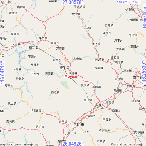
Moyuan GPS coordinates[2]
26° 40' 45.3" North, 117° 33' 0.936" East
| Map corner | latitude | longitude |
|---|---|---|
| Upper-left | 27.30578°, | 116.84714° |
| Center: | 26.67925°, | 117.55026° |
| Lower-right: | 26.04926°, | 118.25339° |
| Map W x H: | 139.7×139.7 km | = 86.8×86.8mi |
| max Lat: | 53.31946° ⇑79.8% North |
| Moyuan: | 26.67925° |
| min Lat: | ⇓20.2% South 18.22056° |
| min Long | Moyuan | max Long |
| 75.07348° | 117.55026° | 134.28917° |
| W 69%⇐ | ⇒31% E |
Elevation
Elevation of Moyuan is 308 m = 1010 ft, and this is 176.8 m = 580 ft below average elevation for this country.
| Max E: |
5622 m = 18445 ft | 36.2% |
| Avg. | 484.8 m = 1591 ft | |
| Moyuan | 308 m = 1010 ft | |
Min E: |
-3 m = -10 ft | 63.8% |
See also: China elevation on elevation.city.
Geographical zone
Moyuan is located in North temperate zone (between Tropic of Cancer and the Arctic Circle). Distance of this Northern Tropic circle is 360.5 km =224 mi to South.| Distance of | km | miles | from Moyuan |
|---|---|---|---|
| North Pole | 7040.6 | 4374.8 | to North |
| Arctic Circle | 4434.7 | 2755.6 | to North |
| Tropic Cancer | 360.5 | 224 | to South |
| Equator | 2966.5 | 1843.3 | to South |


Nearby cities:
15 places around Moyuan: (largest is in red/bold)
• Bailian
25 km =15.5 mi,  223°
223°
• Fukou
29.1 km =18.1 mi,  151°
151°
• Gaoqiao
26 km =16.2 mi,  120°
120°
• Gaotang
14.3 km =8.9 mi,  14°
14°
• Guangming
20.5 km =12.7 mi,  308°
308°
• Guyong
10 km =6.2 mi, 305°
• Huangtan
22.8 km =14.2 mi,  269°
269°
• Lishu
19.1 km =11.9 mi, 120°
• Nankou
14.4 km =8.9 mi,  245°
245°
• Shuinan
24.9 km =15.5 mi,  78°
78°
• Wan’an
27.2 km =16.9 mi,  332°
332°
• Xiamao
16.2 km =10.1 mi,  134°
134°
• Xiayang
29.4 km =18.3 mi,  198°
198°
• Yuankeng
18.4 km =11.4 mi,  60°
60°
• Zhengfang
16.1 km =10 mi, 76°
Sources, notices
• [Note1] Compared only with cities in China existing in our database
• [Src1] Map data: © OpenStreetMap contributors (CC-BY-SA)
• [Src2] Other city data from geonames.org with taken over terms of usage.
• [Src3] Geographical zone / Annual Mean Temperature by Robert A. Rohde @ Wikipedia
