Huangtudian geodata
Huangtudian (Hunan) is a seat of a fourth-order administrative division; located in China in Asia/Shanghai (GMT+8) time zone. In our database, there are 1268 cities with bigger population. Compared to other cities in China, 67.7% of cities are located further ↑North; 64.1% of cities are located further →East and 61.3% of cities have higher elevation than Huangtudian. Note1


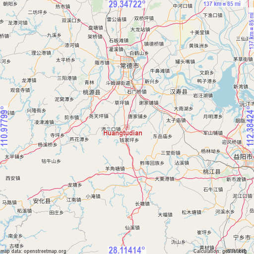
Huangtudian GPS coordinates[2]
28° 43' 57" North, 111° 40' 51.996" East
| Map corner | latitude | longitude |
|---|---|---|
| Upper-left | 29.34722°, | 110.97799° |
| Center: | 28.7325°, | 111.68111° |
| Lower-right: | 28.11414°, | 112.38424° |
| Map W x H: | 137.1×137.1 km | = 85.2×85.2mi |
| max Lat: | 53.31946° ⇑67.7% North |
| Huangtudian: | 28.7325° |
| min Lat: | ⇓32.3% South 18.22056° |
| min Long | Huangtudian | max Long |
| 75.07348° | 111.68111° | 134.28917° |
| W 35.9%⇐ | ⇒64.1% E |
Elevation
Elevation of Huangtudian is 91 m = 299 ft, and this is 393.8 m = 1292 ft below average elevation for this country.
| Max E: |
5622 m = 18445 ft | 61.3% |
| Avg. | 484.8 m = 1591 ft | |
| Huangtudian | 91 m = 299 ft | |
Min E: |
-3 m = -10 ft | 38.7% |
See also: China elevation on elevation.city.
Geographical zone
Huangtudian is located in North temperate zone (between Tropic of Cancer and the Arctic Circle). Distance of this Northern Tropic circle is 588.8 km =365.9 mi to South.| Distance of | km | miles | from Huangtudian |
|---|---|---|---|
| North Pole | 6812.3 | 4233 | to North |
| Arctic Circle | 4206.4 | 2613.7 | to North |
| Tropic Cancer | 588.8 | 365.9 | to South |
| Equator | 3194.8 | 1985.2 | to South |


Nearby cities:
15 places around Huangtudian: (largest is in red/bold)
• Changmaoling
9.7 km =6 mi,  307°
307°
• Deshan
22 km =13.7 mi,  7°
7°
• Dingjiagang
20.3 km =12.6 mi,  324°
324°
• Doumuhu
24.6 km =15.3 mi,  347°
347°
• Luhuatan
26.1 km =16.2 mi,  254°
254°
• Luojiaping
17.6 km =10.9 mi,  145°
145°
• Nijiangping
16.4 km =10.2 mi,  257°
257°
• Qianjiaping
8.3 km =5.2 mi,  164°
164°
• Shimenqiao
19.9 km =12.4 mi,  15°
15°
• Taohuayuan
23.6 km =14.7 mi,  281°
281°
• Wutan
24.8 km =15.4 mi, 162°
• Xiejiapu
16.1 km =10 mi,  45°
45°
• Xujiaqiao
22.2 km =13.8 mi,  335°
335°
• Yangjiaotang
22.7 km =14.1 mi,  194°
194°
• Zhujiapu
11.2 km =7 mi,  74°
74°
Sources, notices
• [Note1] Compared only with cities in China existing in our database
• [Src1] Map data: © OpenStreetMap contributors (CC-BY-SA)
• [Src2] Other city data from geonames.org with taken over terms of usage.
• [Src3] Geographical zone / Annual Mean Temperature by Robert A. Rohde @ Wikipedia
