Wenling geodata
Wenling (Zhejiang) is a populated place; located in China in Asia/Shanghai (GMT+8) time zone. With population of 67,433 people, there are 636 cities with bigger population in this country. Compared to other cities in China, 70.9% of cities are located further ↑North; 89.5% of cities are located further ←West and 95.9% of cities have higher elevation than Wenling. Note1


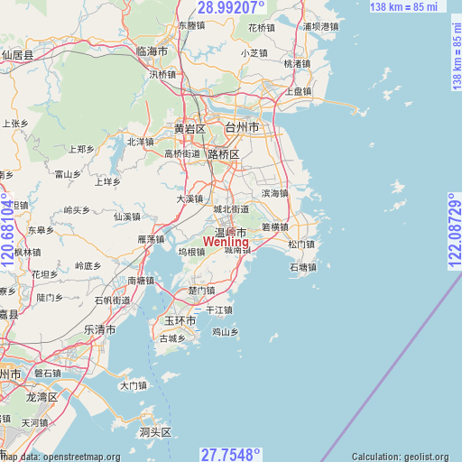
Wenling GPS coordinates[2]
28° 22' 30.864" North, 121° 23' 2.976" East
| Map corner | latitude | longitude |
|---|---|---|
| Upper-left | 28.99207°, | 120.68104° |
| Center: | 28.37524°, | 121.38416° |
| Lower-right: | 27.7548°, | 122.08729° |
| Map W x H: | 137.6×137.6 km | = 85.5×85.5mi |
| max Lat: | 53.31946° ⇑70.9% North |
| Wenling: | 28.37524° |
| min Lat: | ⇓29.1% South 18.22056° |
| min Long | Wenling | max Long |
| 75.07348° | 121.38416° | 134.28917° |
| W 89.5%⇐ | ⇒10.5% E |
Elevation
Elevation of Wenling is 6 m = 20 ft, and this is 478.8 m = 1571 ft below average elevation for this country.
| Max E: |
5622 m = 18445 ft | 95.9% |
| Avg. | 484.8 m = 1591 ft | |
| Wenling | 6 m = 20 ft | |
Min E: |
-3 m = -10 ft | 4.1% |
See also: Wenling elevation on elevation.city.
Geographical zone
Wenling is located in North temperate zone (between Tropic of Cancer and the Arctic Circle). Distance of this Northern Tropic circle is 549.1 km =341.2 mi to South.| Distance of | km | miles | from Wenling |
|---|---|---|---|
| North Pole | 6852 | 4257.6 | to North |
| Arctic Circle | 4246.1 | 2638.4 | to North |
| Tropic Cancer | 549.1 | 341.2 | to South |
| Equator | 3155 | 1960.4 | to South |


Nearby cities:
15 places around Wenling: (largest is in red/bold)
• Chengbei
7.5 km =4.7 mi,  354°
354°
• Chengdong
2.8 km =1.7 mi, 352°
• Chengnan
5.6 km =3.5 mi,  164°
164°
• Chengxi
3.1 km =1.9 mi,  288°
288°
• Daxi
16.6 km =10.3 mi,  307°
307°
• Hengfeng
7.8 km =4.8 mi,  326°
326°
• Huwu
17.8 km =11.1 mi,  278°
278°
• Qinggang
16.8 km =10.4 mi,  215°
215°
• Shamen
14.9 km =9.3 mi,  182°
182°
• Shiqiaotou
6.9 km =4.3 mi,  108°
108°
• Taiping
2.3 km =1.4 mi,  251°
251°
• Wugen
12.7 km =7.9 mi,  243°
243°
• Xinhe
13.5 km =8.4 mi,  29°
29°
• Xinqiao
16.4 km =10.2 mi,  9°
9°
• Zeguo
15.3 km =9.5 mi, 351°
Sources, notices
• [Note1] Compared only with cities in China existing in our database
• [Src1] Map data: © OpenStreetMap contributors (CC-BY-SA)
• [Src2] Other city data from geonames.org with taken over terms of usage.
• [Src3] Geographical zone / Annual Mean Temperature by Robert A. Rohde @ Wikipedia
