Wugen geodata
Wugen (Zhejiang) is a seat of a fourth-order administrative division; located in China in Asia/Shanghai (GMT+8) time zone. In our database, there are 1268 cities with bigger population. Compared to other cities in China, 71.2% of cities are located further ↑North; 88.9% of cities are located further ←West and 84.9% of cities have higher elevation than Wugen. Note1


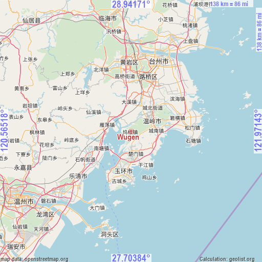
Wugen GPS coordinates[2]
28° 19' 28.488" North, 121° 16' 5.88" East
| Map corner | latitude | longitude |
|---|---|---|
| Upper-left | 28.94171°, | 120.56518° |
| Center: | 28.32458°, | 121.2683° |
| Lower-right: | 27.70384°, | 121.97143° |
| Map W x H: | 137.6×137.6 km | = 85.5×85.5mi |
| max Lat: | 53.31946° ⇑71.2% North |
| Wugen: | 28.32458° |
| min Lat: | ⇓28.8% South 18.22056° |
| min Long | Wugen | max Long |
| 75.07348° | 121.2683° | 134.28917° |
| W 88.9%⇐ | ⇒11.1% E |
Elevation
Elevation of Wugen is 16 m = 52 ft, and this is 468.8 m = 1538 ft below average elevation for this country.
| Max E: |
5622 m = 18445 ft | 84.9% |
| Avg. | 484.8 m = 1591 ft | |
| Wugen | 16 m = 52 ft | |
Min E: |
-3 m = -10 ft | 15.1% |
See also: China elevation on elevation.city.
Geographical zone
Wugen is located in North temperate zone (between Tropic of Cancer and the Arctic Circle). Distance of this Northern Tropic circle is 543.5 km =337.7 mi to South.| Distance of | km | miles | from Wugen |
|---|---|---|---|
| North Pole | 6857.7 | 4261.2 | to North |
| Arctic Circle | 4251.8 | 2641.9 | to North |
| Tropic Cancer | 543.5 | 337.7 | to South |
| Equator | 3149.4 | 1956.9 | to South |


Nearby cities:
15 places around Wugen: (largest is in red/bold)
• Chengdong
13.8 km =8.6 mi,  52°
52°
• Chengnan
12.9 km =8 mi,  89°
89°
• Chengxi
10.7 km =6.6 mi, 51°
• Chumen
11.9 km =7.4 mi,  168°
168°
• Dajing
14.7 km =9.1 mi,  310°
310°
• Haishan
14.9 km =9.3 mi,  222°
222°
• Hengfeng
14.1 km =8.8 mi,  30°
30°
• Huwu
10.3 km =6.4 mi,  322°
322°
• Longxi
14.5 km =9 mi, 166°
• Lupu
15.1 km =9.4 mi,  191°
191°
• Qinggang
8.2 km =5.1 mi, 168°
• Shamen
14.1 km =8.8 mi,  130°
130°
• Taiping
10.4 km =6.5 mi,  61°
61°
• Wenling
12.7 km =7.9 mi, 63°
• Yandang
13 km =8.1 mi,  284°
284°
Sources, notices
• [Note1] Compared only with cities in China existing in our database
• [Src1] Map data: © OpenStreetMap contributors (CC-BY-SA)
• [Src2] Other city data from geonames.org with taken over terms of usage.
• [Src3] Geographical zone / Annual Mean Temperature by Robert A. Rohde @ Wikipedia
